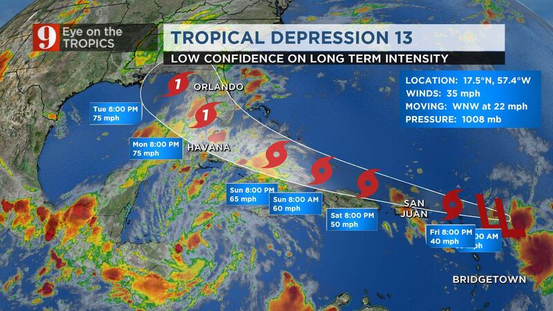
ORLANDO, Fla. — Tropical Depression 13 formed in the central tropical Atlantic late Wednesday, and Tropical Depression 14 formed Thursday morning.
Both systems remained tropical depressions Friday morning. However, Tropical Depression 13 has yet to form a cohesive center.
“Today we are in monitor mode. I do not have a call to action, other than we should always have a hurricane kit on hand,” meteorologist Brian Shields said.
Read: Hurricane Season 2020: How are they named? Who names them? Why? When? Why they retire names?
Shields said these are the scenarios for the development of the storm:
1.) It could fall apart. It is very disorganized right now.
2.) If it manages to hang together, it could run into land and then fall apart.
3.) If it avoids land, it could strengthen further.
Shields said the system is having trouble finding where it wants its center to be.
Happy Friday! I hope you are well.
— Brian Shields (@BrianWFTV) August 21, 2020
As a friendly reminder, social media is a scary train wreck. Tracks change, storms evolve, and NOTHING is set in stone about Tropical Depression 13.
Today we are in MONITOR MODE. I do not... https://t.co/4oCkuD3rkG pic.twitter.com/FEDLT4O6EN
WHAT’S THE DIFFERENCE: What do they mean? Disturbance, depressions, tropical, subtropical storms, hurricanes
“Tropical Depression 13 will be the one we will really be keeping an eye on over next few days,” meteorologist Kassandra Crimi said. “(The) system is still very disorganized, but (it) is expected to strengthen through the day tomorrow.”
Crimi said the system could be a category 1 hurricane near the Florida Keys by midday Monday.
Tropical storm watches are in place for all of Puerto Rico as Tropical Depression 13 is expected to strengthen into a tropical storm Friday.
“Great impacts will be felt in Puerto Rico through the day on Saturday,” Crimi said.
Chief meteorologist Tom Terry is tracking the depressions live on Channel 9 Eyewitness News. Click here to watch live, and click here to download the free WFTV weather app to receive instant updates on the systems.
Tropics update: Both storms remain Tropical Depressions this evening (5pm Aug 20th). TD #13 is the storms we will be watching closely over the next few days. If forecast holds, we could have a Cat 1 storm near the FL Keys by midday Monday. pic.twitter.com/H3gOE4X0yK
— Kassandra Crimi (@KCrimiWFTV) August 20, 2020
TD 13 has not strengthened yet. Tropical Storm Watches issued for the Virgin Islands and Puerto Rico. Here are the 5 pm AST Key Messages. Go to https://t.co/tW4KeGdBFb for details. pic.twitter.com/SuHyoNL1Tv
— National Hurricane Center (@NHC_Atlantic) August 20, 2020
Tropical Depression 13
Most model forecast hint for this wave to reach tropical storm status by Friday. By the weekend, it could be a strong tropical storm.
Intensity models are not in great agreement on the strength of this system, and confidence is low on intensity levels.
Intensity is greatly dependent on how its proximity to and interaction with land.
If it interacts with some of the mountains on the Caribbean islands, the system would remain weak.
If the system stays mainly over warm waters, it will have a better chance of intensifying.
There is high confidence on the forecast track -- it will move west very slowly and be somewhere in the Eastern Caribbean or just north of the Eastern Caribbean by the weekend.
It will likely be traveling over the Central Bahamas on Monday, approaching Florida by the evening.
Visit our hurricane section: EYE ON THE TROPICS.
Visite la sección en español: Temporada de huracanes
Under the current track, we forecast lots of rain for South Florida and the deep tropical humidity also reaching Central Florida by the beginning of next week.
Once this system develops a better-defined center of circulation, we expect to have a more precise track and a probable position for Monday.
The next two names on the list are Laura and Marco.
Tropical Depression 14
The system over the southwestern Caribbean is becoming better organized, with more thunderstorm activity but still lacking a well-defined center of circulation.
The National Hurricane Center labeled this system Tropical Depression 14, with it estimated center south of Jamaica.
This story is forecast to cross the Yucatán Peninsula this weekend as it moves northwest and enters the warm Gulf of Mexico on Monday.
Both systems over the Caribbean guarantees lots of tropical humidity for Florida late this weekend into the beginning of next week.
By the weekend we could have two tropical storms fairly close to Florida -- possibly Laura and Marco.
Did you know? Red skies are a sailor’s delight… except when a slow-moving tropical storm is near
LIVE RADAR: Track thunderstorms live here
DOWNLOAD: WFTV Free Weather App to get alerts for your location
Follow our Severe Weather team on Twitter for live updates:
- Chief meteorologist Tom Terry
- Brian Shields
- Irene Sans
- Kassandra Crimi
- George Waldenberger
- Rusty McCranie
Cox Media Group


