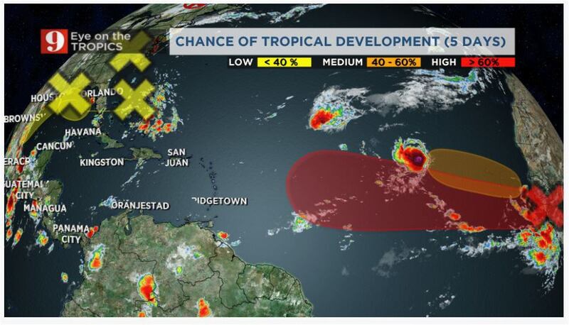
ORLANDO, Fla. — It’s like Mother Nature knows today, September 10, is the peak of hurricane season. On the map, we are watching 6 areas in the tropics.
Let’s start off with the systems already formed: Tropical Storm Paulette and Tropical Storm Rene. Both systems are moving very slowly over the central Atlantic. Although either one of them is forecast to come close to the Caribbean or the U.S. Paulette could affect Bermuda early next week as a hurricane.
Tropical Storm Rene will become a hurricane by Saturday as it meanders in the central Atlantic. Its hurricane status will be short-lived, by Sunday it will go back to tropical storm status. Rene is no threat to the Americas, including Bermuda.
Two tropical waves exiting Africa
Farther east, over the Eastern Atlantic, there are two tropical waves coming out of Africa. The first one just exited the continent and it has a high chance of becoming a tropical system in the next 5 days.
It has a large area of storms and models are showing that this system could become better organized, perhaps becoming a tropical depression or tropical storm by the weekend or early next week.
Just to keep in mind (for counting purposes)
— Irene Sans (@IreneSans) September 10, 2020
There could be 2 more hurricanes added to the list this year by early next week. #Paulette likely to impact #Bermuda. #Rene will meander lost in the central Atlantic, and a short window to live its fullest life as a hurricane. pic.twitter.com/vZMpCWg5ny
Interesting! Busy season! Here are 9 stats for this season, so far
The trajectory shows a westward motion. We will monitor this closely as it is the tropical wave that has the best chance of tracking toward the Caribbean next week. We have plenty of time to monitor this area.
Another wave is going to exit Africa soon and once it moves over land, the tropical wave has a medium chance of becoming a tropical system over the Cabo Verde Islands. As of Thursday morning, the forecast shows this system to follow Rene’s footsteps and stay over the Central Atlantic.
#Rene and #Paulette are forecast by NOAA to become #hurricanes on Sept. 12 & 14, respectively. If forecasts verify, they will be 6th & 7th hurricanes of 2020 Atlantic hurricane season. Only 3 years in satellite era
— Philip Klotzbach (@philklotzbach) September 10, 2020
(since 1966) have had >=7 hurricanes by 9/14: 1995, 2005, 2012 pic.twitter.com/SZrPH2b1gh
Closer to the U.S.
The tropical disturbance that has been near the Carolinas has lost its chance to develop into a tropical system. It is expected to move inland over the Carolinas and bring some isolated storms.
Incredible! Customs officials find nearly $500K stuffed into cushion chair at Miami airport
Today is September 10 - generally considered to be the climatological peak of the Atlantic #hurricane season. In the satellite era (since 1966), ~75% of Atlantic seasons have had >=1 named storm and ~50% of seasons have had >=1 hurricane active on September 10. pic.twitter.com/9kzFArPVpu
— Philip Klotzbach (@philklotzbach) September 10, 2020
A bit more south, and parallel to Florida, east of the Bahamas, there is a large area of disorganized showers and storms. This instability is linked to a surface low-pressure system that will continue to move westward, likely crossing Florida on Friday.
Once this system gets over the Gulf of Mexico it could develop into a tropical system, next week. Conditions are favorable for this system to develop as it moves very slowly to the west-northwest tracking toward the southern Gulf states. The chance of becoming a named tropical system will increase through the weekend.
These two areas of disorganized storms have a low chance to develop within the next 5 days. There is not too much time to develop. The 30% chance disturbance will continue to bring higher rain chance over Florida this the weekend pic.twitter.com/F2q1HlBEaM
— Irene Sans (@IreneSans) September 10, 2020
Another area we are watching is a weak low-pressure system located on the eastern Gulf of Mexico. This system will continue to move slowly west-southwest over the weekend. As it moves parallel, but well offshore of the Texas coastline, this disturbance may become better organized, although at the moment it has a very low chance of becoming a tropical system in 5 days.
We will continue to monitor the evolution of everything that happens in the tropics and bring you the latest on Eyewitness News, on our Eye on the Tropics section, and on our free WFTV Weather App.
Follow our Severe Weather team on Twitter for live updates:
- Chief meteorologist Tom Terry
- Brian Shields
- Irene Sans
- Kassandra Crimi
- George Waldenberger
- Rusty McCranie
© 2020 © 2020 Cox Media Group
© 2020 Cox Media Group


