ORLANDO, Fla. — Nota en español: Perturbación tropical en Caribe occidental con alta probabilidad de desarrollarse este fin de semana
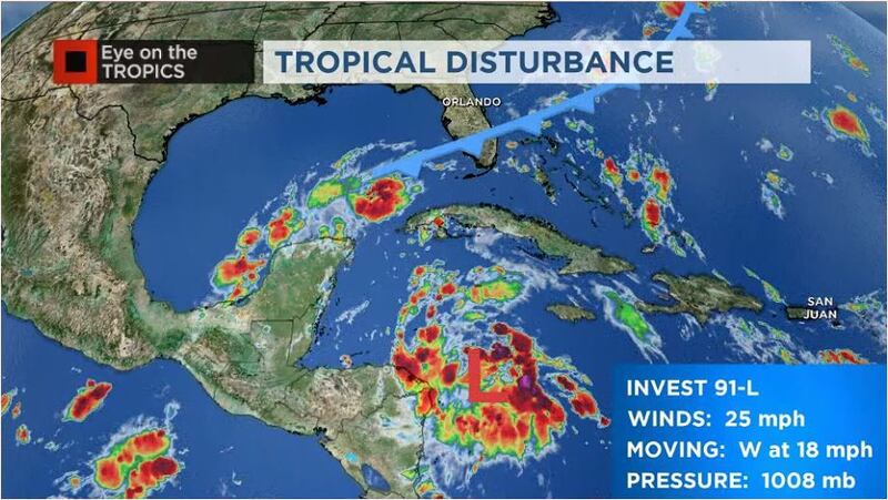
The tropical disturbance labeled, Invest-91L, has a high chance to develop as it approaches the Yucatan Peninsula. Although most models are not really bullish on this system, it is expected to bring high rainfall to Cancun and other adjacent cities in eastern Mexico.
Conditions are favorable for this system to develop, but if it crosses over land, it will limit its strengthening.
Right now the system, although with more storm activity, it is not organized and lacks the center of circulation. Therefore, it is not possible to know if this system will stay on land.
The next name is listed in Gamma (remember we are already using the Greek alphabet).
The scenario is becoming more apparent that this system’s moisture will linger over the southern Gulf of Mexico and likely to be pushed back toward southern Mexico to the west-southwest.
Hurricane season is not over. I am monitoring a system approaching the #Yucatan Peninsula. The next name on the list is #Gamma. Regardless of development, a big rain event coming for #Cancun & nearby areas this weekend. 8 inches of rain is possible. https://t.co/T6HMBt8q5Q
— Irene Sans (@IreneSans) October 1, 2020
Visit our hurricane section: EYE ON THE TROPICS
NEXT TROPICAL WAVE
It is likely that we will have to be monitoring the western Caribbean next week too. There is another tropical wave entering the Caribbean from the east and could have tropical development in the same region during this time. This wave has entered the Caribbean and it is expected to be in the western Caribbean by next week.
This is the time of the year where tail-ends of cold fronts could spin tropical formation, and usually, this happens over the Gulf of Mexico and the western Caribbean.
Depending on how much energy Invest-91L leaves behind, it can fuel the development of the next tropical wave.
We will monitor closely this system through the week, please check back for any updates.
LOCAL WEATHER: A taste of fall: Cold front moves through Central Florida bringing highs in the 70s

Click here to watch Eyewitness News for live updates.
Visite la sección en español: Temporada de huracanes
Follow our Severe Weather team on Twitter for live updates:
- Chief meteorologist Tom Terry
- Brian Shields
- Irene Sans
- Kassandra Crimi
- George Waldenberger
- Rusty McCranie
Cox Media Group


