ORLANDO, Fla — Latest updates on Tropical Storms Laura and Marco.
11 p.m. update
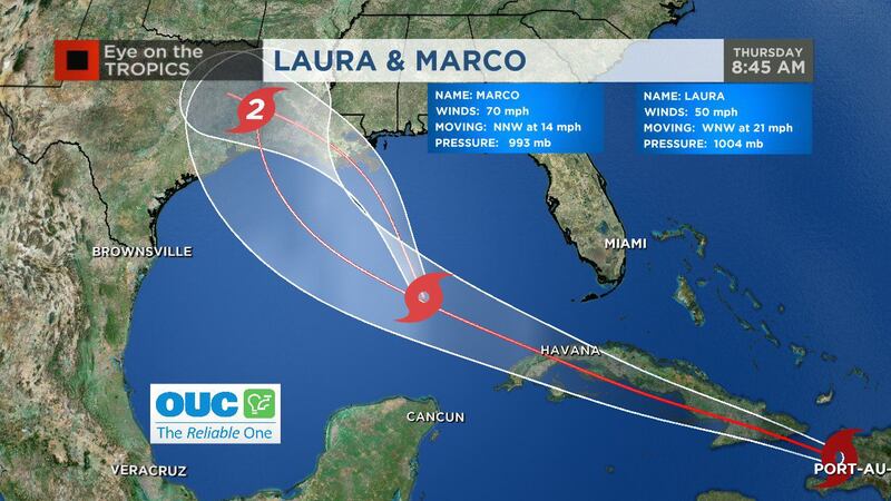
Tropical Storm Laura is a little stronger Sunday night as Marco gets downgraded back to a tropical storm.
Laura is moving west-northwest at 21 mph with maximum sustained winds at 65 mph.
11PM Tropical Storm Laura update, a little strenghtening for now, with significantly more after Laura moves over the Gulf. pic.twitter.com/EP5cln0iI4
— George Waldenberger (@GWaldenWFTV) August 24, 2020
Marco was downgraded from a hurricane to tropical storm, according to the National Hurricane Center.
Marco is moving north-northwest at 12 mph with maximum sustained winds at 70 mph.
A sheared #Marco gets a burst of evening convection. pic.twitter.com/Adtlbf7vwx
— George Waldenberger (@GWaldenWFTV) August 24, 2020
8 p.m. update
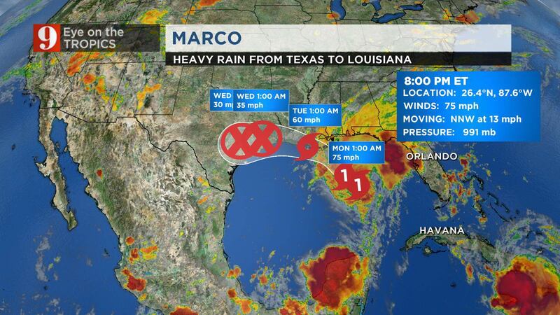
Hurricane Marco is expected to continue its move toward the Louisiana coast on Monday.
Marco is moving north-northwest at 13 mph with maximum sustained winds at 75 mph.
Marco is expected to produce 3 to 5 inches of rain, with some areas of the central U.S. Gulf Coast seeing around 7 inches of rain through Tuesday.
Hurricane #Marco Advisory 14A: Marco Expected to Move Near the Louisiana Coast On Monday. https://t.co/VqHn0u1vgc
— National Hurricane Center (@NHC_Atlantic) August 23, 2020
Tropical Storm Laura is located over eastern Cuba and is forecast to follow the southern coast of Cuba through Monday.
Laura is moving west-northwest at 21 mph with maximum sustained winds at 60 mph.
Laura is forecast to be a hurricane near the coast of Louisiana on Tuesday afternoon.
Tropical Storm #Laura Advisory 16A: Laura Now Located Over Eastern Cuba. https://t.co/VqHn0u1vgc
— National Hurricane Center (@NHC_Atlantic) August 23, 2020
5 p.m. update
Channel 9 meteorologist George Waldenberger said Hurricane Marco has not intensified since it was upgraded to a hurricane Sunday morning.
He said the storm’s track has shifted farther west and may be slower to make land fall. The 5 p.m. track as the storm making land fall on the west Louisiana coast around 2 a.m. Tuesday.
5PM UPDATE: Marco hasn't intensified since this morning, track shifted farther west after Monday morning, may be slower to move over land and farther west as it does. pic.twitter.com/KOOjWmchxu
— George Waldenberger (@GWaldenWFTV) August 23, 2020
Tropical Storm Laura’s 5 p.m. track has it shifting farther south in the short term, possibly passing more over water than Cuba, which Waldenberger said could limit its land interaction.
5pm Laura update: track shifted farther south in the short term, may pass more over water than Cuba, which could limit land interaction. As it moves over the Gulf, strengthening expected. #WFTV pic.twitter.com/OeaGp1ubTW
— George Waldenberger (@GWaldenWFTV) August 23, 2020
Stay tuned to Channel 9 Eyewitness News for updates.
3:30 p.m. update
Channel 9 meteorologist George Waldenberger said a tropical storm watch has been issued for Tropical Storm Laura as it approaches Cuba.
A summary of the tropical storm/hurricane watches and warnings: Florida Keys under a tropical storm watch (Laura), also note part of the southeastern Louisiana & Mississippi Coast under a storm surge warning (Marco). pic.twitter.com/FZnz3ZZIS0
— George Waldenberger (@GWaldenWFTV) August 23, 2020
2 p.m. update
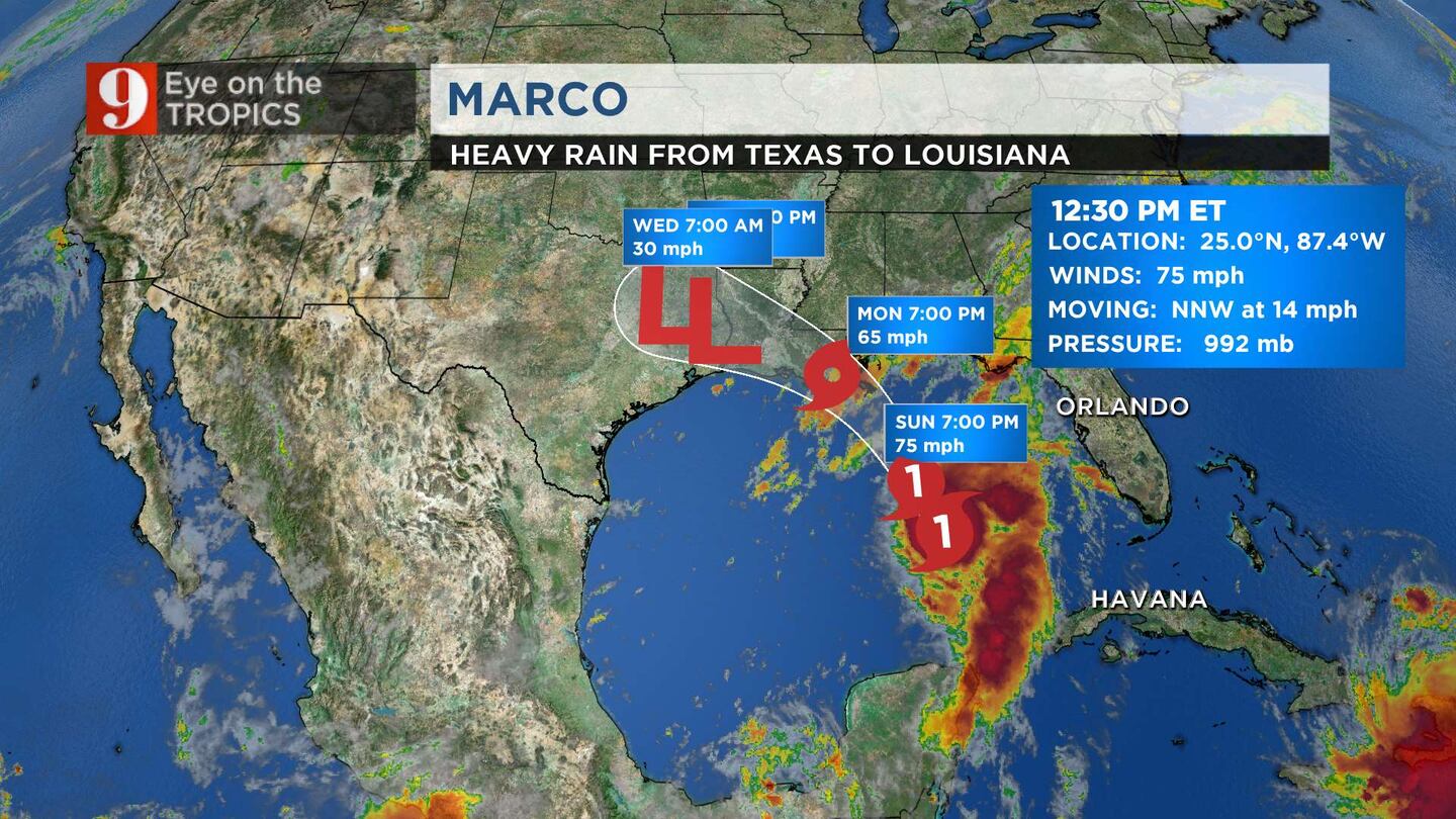
Hurricane Marco continues moving towards the Louisiana coast and is expected to make landfall as a category 1 hurricane sometime late Monday.
According to the National Hurricane Center Marco is about 280 miles from the Gulf Coast, moving at 14 mph with sustained winds of 75 mph.
Hurricane Marco is crossing the Gulf, on forecast track to approach southeastern Louisiana Coast Monday. pic.twitter.com/ydb7AxreDc
— George Waldenberger (@GWaldenWFTV) August 23, 2020
Tropical Storm Laura continues to track west towards Cuba and is expected to reach the Gulf of Mexico early next week.
Laura is about 55 miles east of Cuba moving at 21 mph with sustained winds of 50 mph.
Certified Meteorologist George Waldenberger says as Laura continues to move west, the weather pattern for Central Florida should remain the same with typical afternoon storms.
12:40 p.m. update
Marco has been upgraded to a hurricane, according to a special update from the National Hurricane Center.
Officials said life-threatening storm surge and hurricane-force winds are expected along portions of the Gulf Coast when the storm makes landfall.
As of 12:30 p.m., Marco has maximum winds of 75 mph.
Marco is expected to make landfall on the Louisiana coast as a category 1 hurricane on Monday evening.
#Marco now a hurricane. pic.twitter.com/MymcONeI5w
— George Waldenberger (@GWaldenWFTV) August 23, 2020
11 a.m. update
Tropical Storm Laura is continuing to dump significant amounts of rain in Haiti and the Dominican Republic. Channel 9 meteorologist Kassandra Crimi said the storm remains on track to impact Cuba throughout the day Monday before it heads into the Gulf of Mexico.
As of 11 a.m., Laura’s track pushed even more west, now forecast to ride up the west side of Louisiana.
Crimi said Tropical Storm Marco is on the cusp of becoming a hurricane. It is forecast to reach hurricane strength Sunday afternoon or evening. The latest track still has it forecast to make landfall as a hurricane on the central Gulf Coast.
TS Laura continues to dump significant rain in Haiti and the Dominican Republic. Remains on track to impact Cuba through the day tomorrow before it emerges into the Gulf. TS Marco on the cusp of being a hurricane. Should reach hurricane strength later today or tonight. pic.twitter.com/WZyzQGuLUd
— Kassandra Crimi (@KCrimiWFTV) August 23, 2020
11am EDT: Marco "on the cusp of become a hurricane, but is not quite there yet." pic.twitter.com/WSR5992io1
— George Waldenberger (@GWaldenWFTV) August 23, 2020
8 a.m. update
Tropical Storm Marco continues to gain strength as it continues to cross into the Gulf of Mexico.
TS Marco is located about 360 miles southeast of the Gulf Coast with maximum sustained winds of 70 mph as it moves west-northwest at 13 mph.
TS Marco continues to gain strength. TS Laura not expected to strengthen much today as it will be interacting with a lot of land but is expected to gain strength once it reaches the Gulf, late Monday. With that said, TS Laura still forecast to stay south and west of Central FL pic.twitter.com/yxbiV1cSQi
— Kassandra Crimi (@KCrimiWFTV) August 23, 2020
Both TS Laura and Marco continue to track away from Central Florida and into the Gulf.
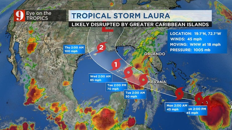
In its 8 a.m. advisory Sunday , The National Hurricane Center said the center of Laura was located about 40 miles northeast of Port Au Prince, Haiti. The storm is still maintaining maximum sustained winds of 45 mph as it moves west-northwest at 18 mph.
11pm Update
Tropical Storm Laura’s strengthening is being delayed by its interaction with Hispaniola and Cuba, but it could intensify into a hurricane once it moves into the Gulf of Mexico.
11pm update for Tropical Storm Laura, direct impacts still far removed from Central Florida. Interaction with Hispanola/Cuba restricting strengthening until Laura can move over the Gulf, then intensify to a hurricane. #WFTV pic.twitter.com/BjCXsa86dD
— George Waldenberger (@GWaldenWFTV) August 23, 2020
Tropical Storm Marco continues to gain strength as it moves towards the gulf coast.
Both TS Laura and Marco continue to track away from Central Florida and into the Gulf.
In its 11 p.m. advisory Saturday, The National Hurricane Center said the center of Laura was located about 25 miles southeast of Santo Domingo, Dominican Republic. The storm is still maintaining maximum sustained winds of 50 mph as it moves west-northwest at 16 mph.
8pm Update
While there have been track adjustments since 5pm, both Tropical Storms Marco and Laura are still forecast to avoid Central Florida.
Be on the lookout for TS Marco to strengthen to hurricane status Saturday evening.
The Florida Keys are under a tropical storm watch as Laura threatens to approach by Monday.
Louisiana, Mississippi, and Alabama could begin to see impacts from both storms within the next 48 hours.
5pm Update
Tropical Storm Laura is forecast to stay well south of Central Florida as the Florida Keys are placed under a tropical storm watch.
Central Florida can expect gusty winds and a wet forecast by Monday.
Tropical Storm Laura's 5pm update, Florida Keys under tropical storm watch. Forecast to stay well south of Central Florida, where we'll have a wet forecast with gusty winds by Monday and waves picking up at our beaches. pic.twitter.com/TGYqtivUaz
— George Waldenberger (@GWaldenWFTV) August 22, 2020
The National Hurricane Center announced big changes to Tropical Storm Marco.
Marco has shifted significantly eastward and is now approaching Coastal Louisiana and Mississippi. It is expected to impact the area within two days.
A storm surge watch and hurricane watch are in place for the North Gulf Coast.
"Big changes" as noted by the NHC on Tropical Storm Marco's forecast track, shifted significantly eastward, approaching Coastal Louisiana/Mississippi area within two days. Storm surge watch and hurricane watch for North Gulf Coast. #WFTV pic.twitter.com/F82lNRpcbH
— George Waldenberger (@GWaldenWFTV) August 22, 2020
2pm Update
Tropical Storm Marco continues to move through the Yucatan Channel and speed remains around 65mph.
The National Hurricane Center expects Marco to become a hurricane sometime Saturday evening.
The one Floridians are paying close attention to is Tropical Storm Laura. Laura still tracks into the Gulf of Mexico early next week as it hits much of the Caribbean this weekend.
If Laura continues to move west, the weather pattern for Central Florida should remain the same with typical afternoon storms.
11am Update
Tropical Storm Laura approaches the Virgin Islands and Puerto Rico today as the storm makes its way through the Caribbean this weekend.
Tropical Storm Marco has winds up to 65 mph and could become a Hurricane by this evening.
Both storms remain on track for the Gulf of Mexico where they will find warmer waters and possible landfall along the Central Gulf Coast later this week.
Rain from TS Laura impacting the island of Puerto Rico this morning. pic.twitter.com/0QEt686kzV
— Kassandra Crimi (@KCrimiWFTV) August 22, 2020
8am Update
Tropical Storms Laura and Marco continue to move into the Gulf of Mexico this weekend.
Laura remains the one that Floridians should watch closely. Through the weekend Laura will have favorable wind conditions but should remain a tropical storm as it passes over the Caribbean, limiting any strengthening.
Late Monday, as Laura enters the Gulf, the storm could strengthen as it finds warmer water.
TS Laura still expected to remain south & west of FL. Through the wknd, it will be impacting Puerto Rico, The D.R., Haiti, and Cuba. We'll be monitoring how the storm holds up with all that land interaction. pic.twitter.com/mL6qlLpluK
— Kassandra Crimi (@KCrimiWFTV) August 22, 2020
Laura is expected to be well west of Central Florida, but local weather will definitely be influenced by this. Expect some wet and stormy weather Monday and Tuesday.
Channel 9 Eyewitness News continues to track all tropical developments. For the latest click here to watch live, and click here to download the free WFTV weather app to receive instant updates on the systems.
Cox Media Group


