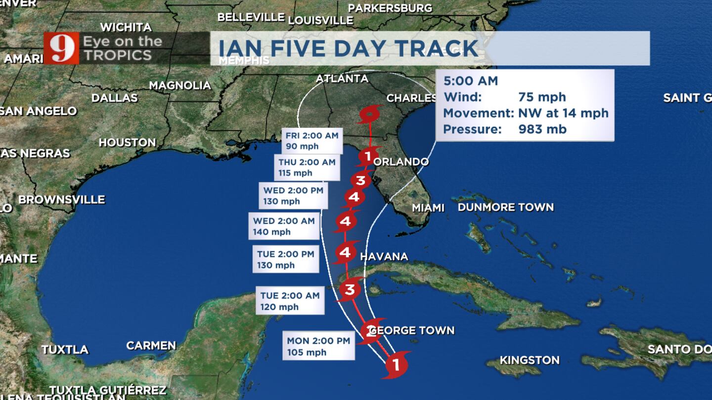
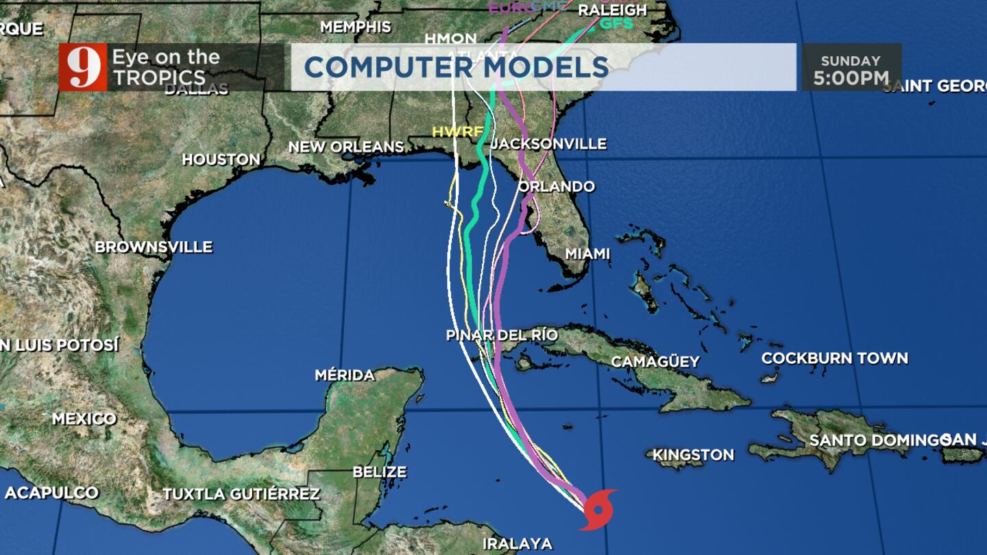
ORLANDO, Fla. — Hurricane Ian officially formed in the western Caribbean on Monday morning and could impact Florida and Central Florida later this week.
>>> STREAM CHANNEL 9 EYEWITNESS NEWS LIVE <<<
>>> DOWNLOAD OUR FREE WEATHER APP <<<
5 a.m. Update
Ian became a hurricane Monday as it moved through the western Caribbean. Impacts to Central Florida could begin as soon as late Tuesday or early Wednesday.
11 p.m. Update
The center of Ian track shifts east, a bit closer to Central Florida, which means it is intensifying now.
The lower Florida Keys is under a tropical storm warning.
Parts of the Florida Keys under storm surge watch and parts of Southwest Florida are under tropical storm watch.
Tropical Storm #Ian Advisory 12: Ian Continues to Strengthen. Expected to Produce Significant Wind and Storm Surge Impacts In Western Cuba. https://t.co/tW4KeFW0gB
— National Hurricane Center (@NHC_Atlantic) September 26, 2022
8 p.m. Update:
Ian is strengthening and becoming better organized, with winds now to 60 mph.
Right now, it’s 430 miles from the western tip of Cuba, now beginning to move more northwestward.
5 p.m. Update:
Tropical Storm Ian is still disorganized but expected to rapidly intensify over the next few days.
The lower Florida Keys have been placed under a tropical storm watch.
Tropical Storm #Ian Advisory 11: Ian Expected to Produce Significant Wind and Storm Surge Impacts In Western Cuba. Tropical Storm Watch Issued For the Lower Florida Keys. https://t.co/tW4KeFW0gB
— National Hurricane Center (@NHC_Atlantic) September 25, 2022
Once Ian moves into the Eastern Gulf, uncertainty grows on the exact track.
Overall, the track shifted a little farther east, closer to Central Florida.
Ian's 5pm track update...center of Thursday portion of the cone shifted east a little - slightly closer to Central Florida. pic.twitter.com/Ua7eh2EXjl
— George Waldenberger (@GWaldenWFTV) September 25, 2022
11 a.m. Update:
Ian remains a tropical storm with winds at 50 miles per hour.
There was no noticeable shift east or west for the latest track.
Here are the 11am EDT Sunday 25 Sep Key Messages for Tropical Storm #Ian.
— National Hurricane Center (@NHC_Atlantic) September 25, 2022
A Hurricane Warning is now in effect for portions of western Cuba.
Latest Advisory: https://t.co/tnOTyfOjMY pic.twitter.com/kQVDbE5768
We anticipate this storm to rapidly intensify as it approaches SW Cuba.
Ian is expected to reach hurricane status on Sunday and could be a major hurricane by late Monday night.
Ian will bring significant impacts to Grand Cayman and portions of Cuba.
Next week, parts of Florida will feel the impacts of this storm.
Here is an infographic on how to understand the @NHC_Atlantic tropical cyclone cone.#FLKeys #KeyWest #FLwx #Keyswx pic.twitter.com/MRKXmLisZz
— NWS Key West (@NWSKeyWest) September 25, 2022
There is a lot of uncertainty that remains in the long-range forecast.
Jogs in the track both East and West are still possible, meaning that it is too early to say if it’s a Panhandle storm, a Cedar Key storm, or a Tampa storm.
Central Florida will likely feel some impacts regardless, but the magnitude of these impacts could change.
Previous Story:
Tropical Storm Ian is expected to become a major hurricane as it approaches Cuba within the next 48 hours.
Hurricane warnings are in place for Western Cuba as Ian approaches.
Read: Hurricane supply checklist: What should you include in your kit?
There’s still a lot of uncertainty in models once Ian moves north of Cuba.
The forecast keeps Ian as a major hurricane on our west coast, making landfall near the Big Bend Coast. Due to the uncertainty, we can’t pin down Ian’s impact on our area quite yet.
Read: Eye on the Tropics: Peak of hurricane season update and safety tips
Ian is expected to impact Central Florida on Wednesday and Thursday
Squally weather, heavy rain and tornadic potential will be our biggest concerns.
Tropical Storm #Ian Advisory 9A: Ian Forecast to Begin Rapidly Strengthening Later Today. Risk of Significant Wind and Storm Surge Impacts Increasing For Western Cuba. https://t.co/tW4KeFW0gB
— National Hurricane Center (@NHC_Atlantic) September 25, 2022
>>> WATCH LIVE RADAR HERE <<<
Follow our Severe Weather team on Twitter for live updates:
Visit our hurricane section: EYE ON THE TROPICS
Click here to download the free WFTV news and weather apps, click here to download the WFTV Now app for your smart TV and click here to stream Channel 9 Eyewitness News live.
©2022 Cox Media Group


