ORLANDO, Fla. — Tropical Depression 9 formed Friday morning and could impact Florida by next week. Read live updates below:
>>> STREAM CHANNEL 9 EYEWITNESS NEWS LIVE <<<
>>> DOWNLOAD OUR FREE WEATHER APP <<<
11 p.m. update
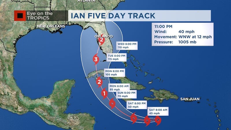
TropIcal Storm Ian has officially formed.
The 11 p.m. updated forecast track hasn’t changed much since 5 p.m., and it’s too soon to know location of impacts, Channel 9 meteorologist George Waldenberger said.
READ: Timeline for Tropical Depression 9: Here’s what to expect
The forecast cone indicates the potential of a major hurricane nearing the Florida Peninsula, or just west, by Tuesday night or Wednesday.
Waldenberger advises residents to go over their hurricane plan this weekend.
See our in-depth coverage in the video below:
11PM UPDATE: Tropical Storm Ian forms, updated track hasn't changed much since 5pm update. Forecast to be at or near major hurricane strength before approaching Florida. Too soon to know exact location of impacts - go over your hurricane plan this weekend. pic.twitter.com/40yckj1Bqe
— George Waldenberger (@GWaldenWFTV) September 24, 2022
5 p.m. update
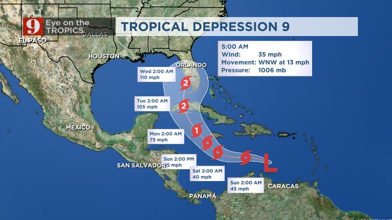
Tropical Depression Nine is still churning across the Caribbean but is expected to become a tropical storm soon, and then a hurricane by the weekend.
The 5 p.m. track shifted slightly west with new model data.
Read: Timeline for Tropical Depression 9: Here’s what to expect
Expect the potential for tropical storm/hurricane impacts in Central Florida on Wednesday.
The threat of flooding, rain and strong winds will all depend on storm’s track, which is still very uncertain at this time.
Read: Hurricane supply checklist: What should you include in your kit?
Tropical Storm Hermine formed far west of Africa’s coastline. Active systems include Hurricane Fiona, tropical storms Gaston and Hermine, Tropical Depression Nine and a disorganized low.
Stream Tom Terry live on Channel 9 Eyewitness News.
Hermine formed in the Eastern Atlantic just now, so looks like Caribbean system will get the name Ian.... pic.twitter.com/i8rRif6AQg
— George Waldenberger (@GWaldenWFTV) September 23, 2022
4:40 p.m. update
Tropical Storm Hermine just formed in the eastern Atlantic, so the Caribbean system will instead likely get the name Ian.
Hermine formed in the Eastern Atlantic just now, so looks like Caribbean system will get the name Ian.... pic.twitter.com/i8rRif6AQg
— George Waldenberger (@GWaldenWFTV) September 23, 2022
4:20 p.m. update
Gov. Ron DeSantis issued an executive order on Friday declaring a State of Emergency for 24 counties in the potential path of Tropical Depression 9.
DeSantis also requested a federal pre-landfall Emergency Declaration in anticipation of impacts from the storm. His office said that declaration will make resources and support available as well as free up funding sources for emergency protective measures. Under the emergency order, members of the Florida National Guard will be activated and on standby awaiting orders.
The state of emergency applies to: Brevard, Broward, Charlotte, Collier, DeSoto, Glades, Hardee, Hendry, Highlands, Hillsborough, Indian River, Lee, Manatee, Martin, Miami-Dade, Monroe, Okeechobee, Osceola, Palm Beach, Pasco, Pinellas, Polk, Sarasota and St. Lucie.
1:30 p.m. update
Channel 9 meteorologist Rusty McCranie said there is still a lot of variability in where the tropical depression will head. You can see the latest models in his tweet below.
The new GFS model now shows a much slower and slightly westward track towards the panhandle. A huge difference in location and forward speed compared to Euro. This should clue you into a low confidence forecast beyond this weekend. Watch and wait mode. pic.twitter.com/pQMcv5xNPv
— Rusty McCranie (@RMcCranieWFTV) September 23, 2022
With the approach of a tropical system early next week...what should I do? pic.twitter.com/vLxILwID0c
— Rusty McCranie (@RMcCranieWFTV) September 23, 2022
11 a.m. update
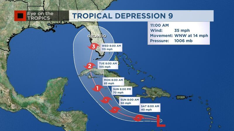
Tropical Depression 9 is forecast to continue to strengthen as it moves across the Caribbean over the weekend with a turn towards South Florida early next week.
The National Hurricane Center said this is forecast to become a major Category 3 hurricane around southwest Florida on Wednesday morning.
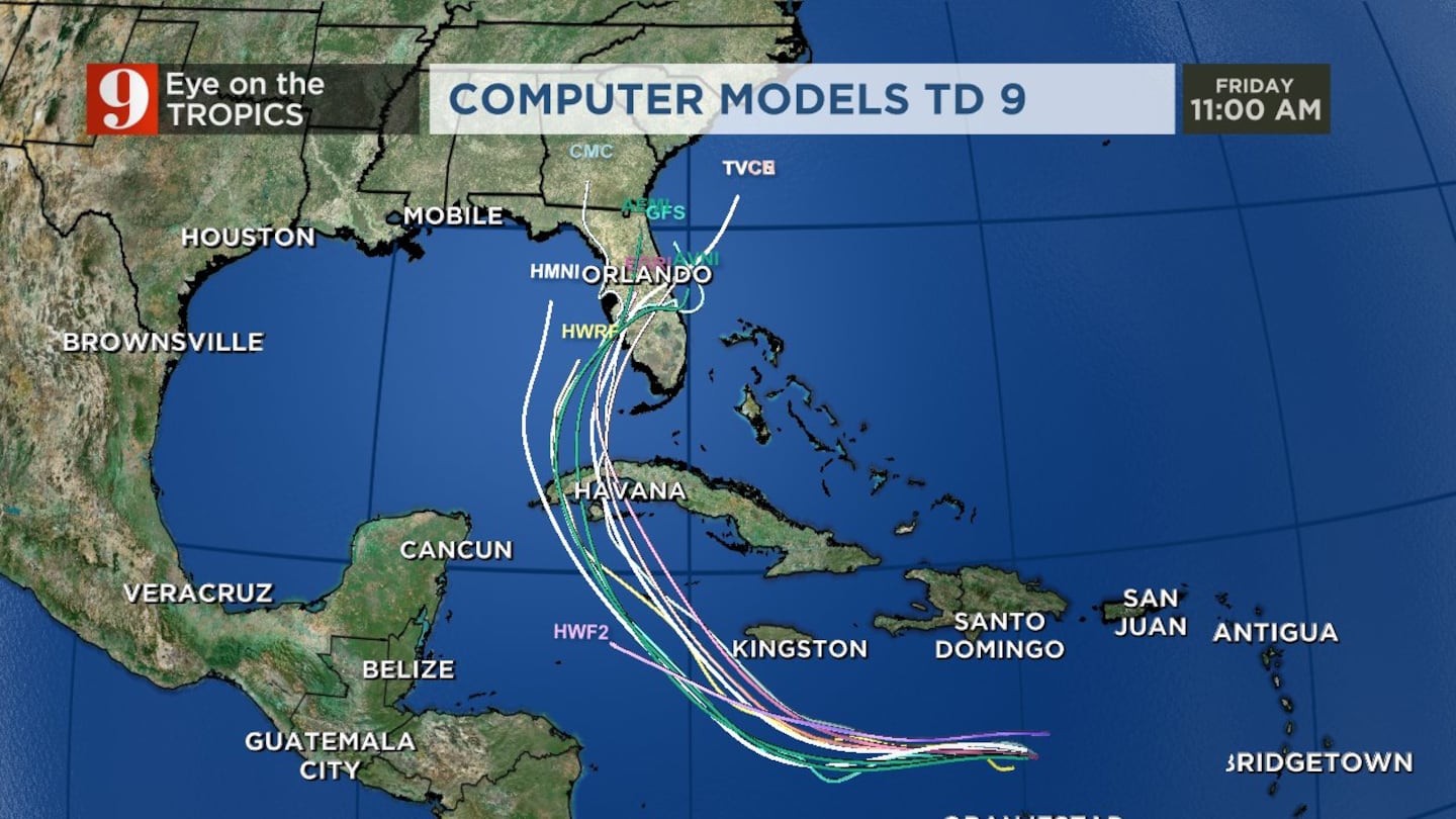
The latest computer models on the track of Tropical Depression 9 shows it clustered over western Cuba and then heading toward southwest Florida.
“Remember, these are models, and the track can and will change,” meteorologist Rusty McCranie said.
Residents should start their initial preparation Friday and refresh their hurricane supply kits.
By Saturday, we should know if there will be impacts to Florida. If that is the case, more hurricane preparation will be needed.
Sunday is when we will know exactly what kind of impacts we will see.
Watch live updates on Channel 9 Eyewitness News at Noon.
Download the WFTV news and weather apps here for regular updates.
11am Friday TD 9: Tropical Depression 9 is forecast to continue to strengthen as it moves across the Caribbean over the weekend, with turn towards South Florida early next week. The NHC now has this becoming a major Category 3 hurricane around SW Florida Wednesday morning. pic.twitter.com/3pkJ5eCj5t
— Rusty McCranie (@RMcCranieWFTV) September 23, 2022
Latest computer models on the track of TD 9. Clustered over western Cuba and then SW Florida. Remember, these are models, and the track can and will change. pic.twitter.com/X73iSLcyJq
— Rusty McCranie (@RMcCranieWFTV) September 23, 2022
9 a.m. update
TD9 is currently in the central Caribbean moving west-northwest at 13 mph.
Tropical Depression 9 formed, as expected. It will become a tropical storm, and then a hurricane. The next name on the list is Hermine. I'm going over exactly what this means for us, now on Channel 9. pic.twitter.com/nMbFFlvjtt
— Brian Shields, WFTV (@BrianWFTV) September 23, 2022
The tropical disturbance is forecast to develop into a hurricane by this weekend.
Read: Eye on the Tropics: Peak of hurricane season update and safety tips
The storm could be near western Cuba by early next week.
The forecast models for TD9 currently have the system moving toward the west coast of Florida or South Florida.
Tropical Depression #Nine Advisory 1: Tropical Depression Forms Over the Central Caribbean Sea. https://t.co/tW4KeFW0gB
— National Hurricane Center (@NHC_Atlantic) September 23, 2022
Florida residents are encouraged to have their hurricane plans in place, but full-throttle preparations are not needed at this point.
The path of tropical systems can be unpredictable over time, so there is still a chance that Central Florida will not see a direct impact from TD9.
Channel 9 meteorologists will continue to monitor TD9 and will provide updates on Eyewitness News.
Watch: Hurricane Fiona to bring rough surf, strong rip currents to Volusia County beaches
>>> WATCH LIVE RADAR HERE <<<
Follow our Severe Weather team on Twitter for live updates:
Visit our hurricane section: EYE ON THE TROPICS
Click here to download the free WFTV news and weather apps, click here to download the WFTV Now app for your smart TV and click here to stream Channel 9 Eyewitness News live.
©2022 Cox Media Group


