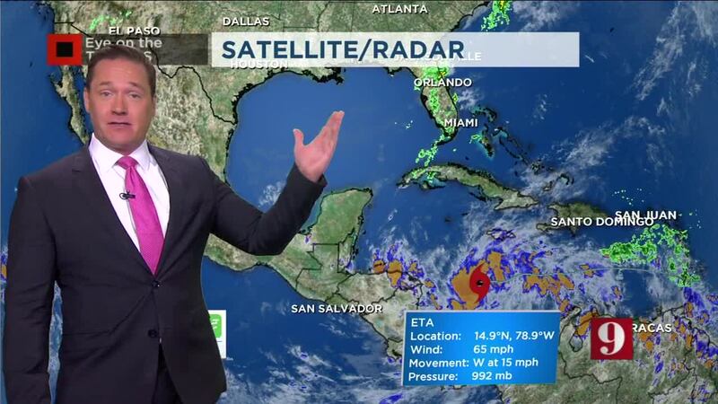
ORLANDO, Fla. — 10 p.m. update:
Hurricane Eta is expected to strengthen to Category 5 status before Tuesday morning’s landfall on the Caribbean Coast of Nicaragua.
Certified meteorologist George Waldenberger said the storm will spend spend days over Central America before reemerging back over the Caribbean and reorganizing.
By the weekend, it is forecast to loop back over the Caribbean and begin reorganizing and head the other direction.
UPDATE: ULA Atlas V rocket launch of spy satellite postponed to Wednesday
Hurricane Eta expected to strengthen to Category 5 status before tomorrow morning's landfall on the Caribbean Coast of Nicaragua, then spend days over Central America before reemerging back over the Caribbean and reorganizing. pic.twitter.com/a7w4OfYrxt
— George Waldenberger (@GWaldenWFTV) November 3, 2020
5:20 p.m. update:
Eta is now a Category 4 hurricane and strengthening.
The storm is expected to make landfall Tuesday near the Honduras-Nicaragua border.
Read: ULA Atlas V rocket launch set to launch spy satellite to space on election day
Chief Meteorologist Tom Terry said the storm is expected to weaken before moving back over water again.
Terry shows you the storm’s track LIVE on Channel 9 Eyewitness News. Click here to watch live.
Monday 4pm: #Eta now a Cat 4 hurricane, and strengthening. Landfall on Tuesday near the Honduras/Nicaragua border. Expected to weaken, then move BACK OVER water again! Lots of track for more than a week...#2020 #EyeonTropics pic.twitter.com/hpk9i7QFRX
— Tom Terry (@TTerryWFTV) November 2, 2020
1 p.m. update:
Hurricane Eta is now a Category 3 hurricane with maximum sustained winds at 120 mph. Eta could make landfall as a strong category 4 hurricane or maximum category 5 hurricane late Monday evening.
Hurricane-force winds extend outward up to 25 miles from the center and tropical-storm-force winds extend outward up to 115 miles.
12 p.m. update:
Intense rain already causing flooding for some inland areas in Honduras. This town below is well to the northwest of Honduras, but Eta’s outer bands have already arrived and the rain will only become more intense.
#HoyMismo #Honduras | #Huracán #ETA deja inundaciones en barrios y colonias de El Progreso, Yoro. Javier Castillo informa: pic.twitter.com/9eGOo9rxqA
— Noticieros Hoy Mismo (@HoyMismoTSI) November 2, 2020
11 a.m. update:
Hurrican Eta continues to intensify and it is expected to reach major category status later this afternoon.
It is located about 115 miles east of Cabo Gracias a Dios near the Nicaragua/ Honduras border.
Hurricane hunters investigating the system have found higher gusts than 110mph.
Eta is expected to make landfall later tonight near the Nicaragua/Honduras border and it is expected to quickly lose strength as it moves inland. Although the winds will be decreasing, torrential rains will cause landslides and flash flooding for inland portions of Central America.
Rainfall between 15-20 inches is possible and up to 30 inches of rain is forecast for some locations in Central America.
#Eta tocará tierra cerca de la frontera de #Nicaragua #Honduras esta noche como un huracán de cat 4. La amenaza del viento disminuirá a medida que la tormenta se mueva tierra adentro, pero la amenaza de lluvias intensas sigue al interior. Inundaciones repentinas y deslizamientos. https://t.co/lL7o5VJchm
— Irene Sans (@IreneSans) November 2, 2020
Earlier version:
Eta became a hurricane overnight, with 110 mph winds. The storm is the 12th Atlantic hurricane of the 2020 season.
Hurricane Eta could bring life-threatening storm surge, damaging winds, flash flooding, and landslides to portions of Central American, especially in Nicaragua and Honduras.
The center of Eta is expected to approach the northeastern coast of Nicaragua during the day on Monday and make landfall late Monday or early Tuesday morning.
Photos: Halloween 2020 Blue Moon brightens the night sky
As Eta slowly approaches Nicaragua, the hurricane has a good chance to intensify and it could become a major hurricane when it makes landfall.
READ: Record-tying storm: Tropical Storm Eta becomes 28th named system of 2020
Visit our hurricane section: EYE ON THE TROPICS
Visite la sección en español: Temporada de huracanes
Follow our Severe Weather team on Twitter for live updates:
- Chief meteorologist Tom Terry
- Brian Shields
- Irene Sans
- Kassandra Crimi
- George Waldenberger
- Rusty McCranie
Cox Media Group


