>> CLICK HERE FOR LIVE DOPPLER 9 RADAR <<
Evening update:
ORLANDO, Fla. — Storms developed lots of hail across Central Florida. Hail reports poured into Channel 9 from viewers. Reports of golf-sized hail in Kissimmee.
At 9:30 p.m. the storms are gradually weakened and will continue diminishing through the 11 p.m. hour.
Remember these are typical summer-like storms. With these types of storms severe weather could always happen including damaging wind gusts, hail, and the risk for an isolated tornado to form.
Viewer’s pictures: Hail reports across Central Florida
Expect summer-like afternoon storms through the weekend.
"No es Snow nena, Es ICE!!!!"
— Irene Sans (@IreneSans) May 22, 2020
Granizada que cayo esta noche en Sanford (y en otras muchas partes de Florida Central!
Gracias Delilah, I hope your window is okay.
It's not snow baby, it's ICE!
Hail storm in Sanford this Thursday and across many other cities in Central Florida. pic.twitter.com/0DUDSzb0ra
Heavy rain and a quite a bit of lightning with this storm in Winter Springs! Sounds like the summer wet season is kicking off! #wftv #stormalert9 @WFTVWeather @NWSMelbourne pic.twitter.com/YYqiUcknjy
— Kenny Gibson (@KGibsonTV9) May 21, 2020
Hail here in Poinciana. Small Pea Sized. Wind got really really bad. Relocate garbage cans down the street. #stormalert9 pic.twitter.com/GrPxC06uwy
— Roman Hudson (@TheRomanD) May 21, 2020
#stormalert9 Lake Mary, FL! pic.twitter.com/KkvbUjXYh1
— Kimberley Reller ✨ (@kimreller) May 22, 2020
Late afternoon update:
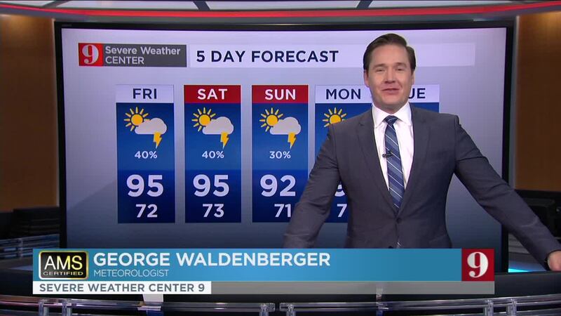
The warm pattern will continue through the rest of the week, with highs reaching the low to mid-90s and afternoon storms ramping up just in time for the weekend.
The sea breezes, from both coasts, have triggered some scattered strong storms, a couple of storms have turned severe. We could have a few more severe cells during the next few hours across inland locations. The sea breeze is noticeable on Doppler 9 moving west, as the west coast sea breeze has already developed some storms over Sumter and Lake counties and they move eastward. Both sea breezes will collide and more storms will likely develop across Seminole, Orange, and northern Osceola counties.
Stay weather aware, as some storms have a history of developing strong winds and small hail.
Expect the storm chance to increase to 40 to 50 percent for the weekend, mainly affecting inland locations.
Quarter-size hail on the east side of Orange Country @WFTVWeather @GWaldenWFTV @TTerryWFTV @IreneSans pic.twitter.com/7BkNr2SiTf
— Christopher Heath (@CHeathWFTV) May 21, 2020
Hail in #LakeNona from @WFTV viewer Irma Calderin. Wow! ⛈@IreneSans @BrianWFTV @RMcCranieWFTV pic.twitter.com/DqE9RLhEyU
— Nancy Alvarez (@NAlvarezWFTV) May 22, 2020
WATCH LATEST: Eye in the Tropics Update
Click here to watch our newscasts live
See our five-day forecast below:
>> CLICK HERE FOR LIVE DOPPLER 9 RADAR <<
DOWNLOAD OUR FREE WFTV WEATHER APP TO RECEIVE ALERTS
Follow our Severe Weather team on Twitter for live updates:
- Chief meteorologist Tom Terry
- Brian Shields
- Irene Sans
- Kassandra Crimi
- George Waldenberger
- Rusty McCranie
© 2020 Cox Media Group


