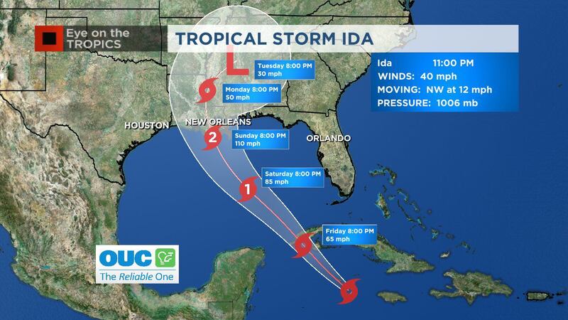
ORLANDO, Fla. — Tropical Storm Ida formed over the Caribbean Sea on Thursday afternoon. Meteorologists are also monitoring two other disturbances in the Atlantic. Read updates below:
11:10 p.m. update
Hurricane watches have been issued for parts of the Northern Gulf coast after Tropical Storm Ida formed Thursday afternoon, including coastal Louisiana and Mississippi.
Channel 9 Chief Meteorologist Tom Terry said storm surge watches extend as far east as the Alabama and Florida line.
The storm could make landfall as a major hurricane, Terry said.
#Ida 11pm Thursday: Still tracking toward north-central Gulf coast late this weekend and could make landfall as a major hurricane though. Hurricane watches as out along Louisiana and Mississippi coasts. pic.twitter.com/8BJyBahXmP
— Tom Terry (@TTerryWFTV) August 27, 2021
5:40 p.m. update
Tropical Storm Ida formed over the Caribbean Sea on Thursday afternoon.
>>> STREAM CHANNEL 9 EYEWITNESS NEWS LIVE <<<
“We officially have Ida, which will be a hurricane this weekend and causing trouble in the north central Gulf coast,” chief meteorologist Tom Terry said.
Click here to watch his live forecast on Channel 9 Eyewitness News.
Recon finding enough organization and winds to classify #Ida. Their data will help NHC build the wind field forecasts alongside forecast models going forward. pic.twitter.com/rG9NVJbbkb
— Tom Terry (@TTerryWFTV) August 26, 2021
11:30 a.m. update
A tropical depression formed over the west-central Caribbean Sea. The National Hurricane Center issued a tropical storm warning for the Cayman Islands and portions of western Cuba.
Meteorologist Rusty McCranie said heavy rain and flooding is the greatest concern with the storm.
He said eight to 12 inches of rain, with isolated amounts of up to 20 inches are expected.
READ: Atlantic hurricane season shows no signs of slowing down, NOAA says in mid-season update
McCranie said Jamaica could see six to 10 inches of rain as well.
The storm is expected to continue strengthening over the next few days.
The National Hurricane Center said the depression is expected to become a tropical storm on Thursday night and become a hurricane when it is near western Cuba or over the southeastern Gulf of Mexico.
Tropical Storm Warning in effect for the Cayman Islands and western Cuba. Heavy and flooding the greatest concern. 8-12" of rain with isolated amounts up to 20" are expected. Jamaica could see 6-10" of rain as well. pic.twitter.com/TEhClxsxnl
— Rusty McCranie (@RMcCranieWFTV) August 26, 2021
Two other disturbances are being monitored in the Atlantic.
7 a.m. update
A disturbance near Jamaica could become a tropical depression soon and the National Hurricane Center is monitoring two other disturbances in the Atlantic.
The system near Jamaica continues to become better organized. Forecasters said the disturbance is expected to become a tropical depression or tropical storm late Thursday or on Friday.
The National Hurricane Center said the system is forecast to be over the northwestern Caribbean Sea near the Cayman Islands tonight, near Cuba and the Yucatan Peninsula of Mexico on Friday, and into the Gulf of Mexico this weekend.
See: Tropical system terms explained
The system could bring dangerous impacts from storm surge, wind, and heavy rainfall to portions of the coasts of Louisiana, Texas, and the Mexican state of Tamaulipas late this weekend and early next week, weather officials said.
It has a 90% chance of forming over the next 48 hours.
Meteorologists are also monitoring two other disturbances. One of the systems is near Bermuda.
The National Hurricane Center said a tropical depression is likely to form late this week or this weekend while the system moves slowly northeastward over the central Atlantic.
It has a 40% chance of forming over the next 48 hours and an 80% chance of forming over the next five days.
Forecasters said a tropical wave over the far eastern tropical Atlantic is producing disorganized showers and thunderstorms.
They believe the storm could develop over the next several days as it moves over the eastern tropical Atlantic.
READ: How many times has Walt Disney World had to close for a hurricane?
The disturbance has a 20% chance of forming over the next 48 hours and a 30% chance of forming over the next five days.
Visit our hurricane section: EYE ON THE TROPICS
Follow our Severe Weather team on Twitter for live updates:
Click here to download the WFTV weather app for live updates to your phone, and click here to stream weather coverage on the WFTV now app.
Cox Media Group


