
ORLANDO, Fla. — Channel 9 meteorologists are monitoring a system in the Gulf of Mexico that may become our next named storm.
▶ WATCH CHANNEL 9 EYEWITNESS NEWS

9 p.m. update:
Development chances are increasing again for a disturbance in the far Southwestern Gulf tonight.
Rain could be a big issue for parts of central and south Florida through mid-next week
4:20 p.m. update:
The threat of tropical development is increasing for next week.
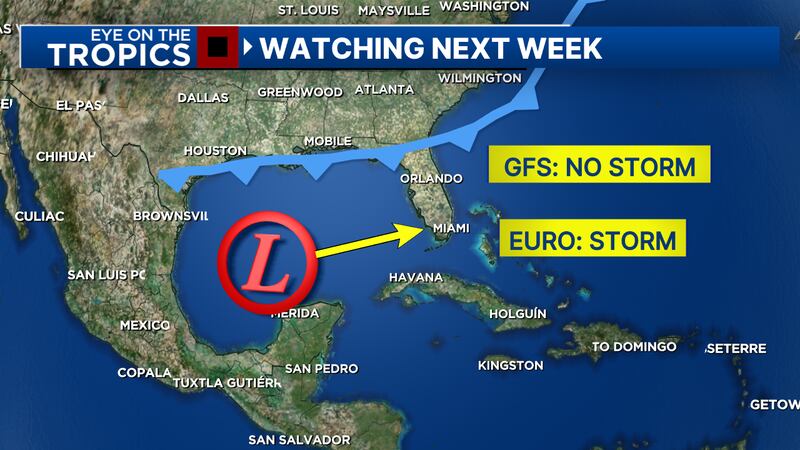
Friday’s computer models are indicating some organization of a complex in the Gulf this weekend, with movement toward the west coast of Florida early next week.
The National Hurricane Center has also raised the chance of development to 50%.
The system would likely move across the state in the Tuesday-Wednesday time frame of next week.
It is too early to know possible impacts in Central Florida, but heavy rainfall will likely be a concern regardless of development.
Next week, widespread three to five inches of rainfall look likely, with areas in Southwest Florida and the Treasure Coast potentially receiving five to seven inches.
Stay with Channel 9 this weekend for updates on this developing system.
0 of 5


Update:
Chief Meteorologist Tom Terry said that with extra energy imported from the Pacific, the odds are higher that we’ll have a tropical system form in the Gulf.
Terry said it is tracking toward Florida by Tuesday or Wednesday next week, according to the GFS & Euro models.
Original story:
It is still hard to tell where the system will go and how strong it will be.
Some computer models show the system developing into a tropical storm and moving over Florida, but others keep it as a disorganized low-pressure area.
Read: Hurricane Helene recovery: How you can help
Though the warm Gulf waters should help to strengthen the storm, wind shear is also working against its development.
Regardless of the development, the storm system should bring a lot of rain and storms to our area for most of next week.
Read: Biden visits Florida to survey Hurricane Helene damage
Hurricane Kirk continues to gain strength in the Central Atlantic.
Kirk is a major Category 4 hurricane with maximum sustained winds around 145 mph.
Read: Action 9: Watch out for donation scams following Hurricane Helene
Thankfully, Kirk is forecast to stay out to sea.
Tropical Storm Leslie is right behind Kirk and is also slowly moving through the Central Atlantic.
Channel 9 will continue to monitor all active systems in the tropics and provide updates on Eyewitness News.
Follow our Severe Weather team on X for live updates:

©2024 Cox Media Group


