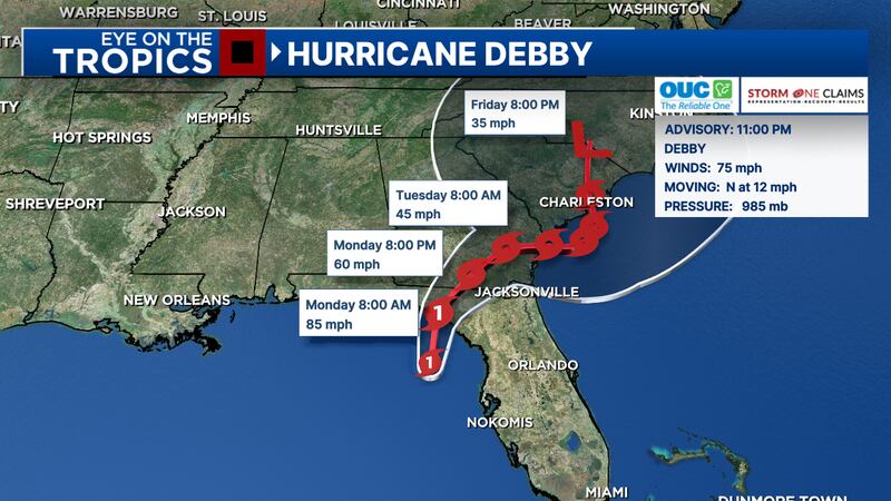
Debby is now a hurricane as it approaches the Northeastern Gulf Coast.
The track has shifted a bit west, meteorologist George Waldenberger said.
Hurricane #Debby Advisory 11: Debby Becomes a Hurricane as it Approaches the Northeastern Gulf Coast. Will Bring a Major Flood Threat to the Southeastern United States This Week. https://t.co/tW4KeGe9uJ
— National Hurricane Center (@NHC_Atlantic) August 5, 2024
10 p.m. update
Photos pour in from across the state as Tropical Storm Debby approaches Florida.
Hurricane Debby Cedar Key, FL—Cedar Key Fire Rescue said the number four bridge will remain closed until all hazards are removed. Officials said many roads on the island are still underwater. (Cedar Key Fire Rescue/Cedar Key Fire Rescue)
Hurricane Debby Cedar Key, FL—Cedar Key Fire Rescue said the number four bridge will remain closed until all hazards are removed. Officials said many roads on the island are still underwater. (Cedar Key Fire Rescue/Cedar Key Fire Rescue)
Hurricane Debby Cedar Key, FL—Cedar Key Fire Rescue said the number four bridge will remain closed until all hazards are removed. Officials said many roads on the island are still underwater. (Cedar Key Fire Rescue/Cedar Key Fire Rescue)
Hurricane Debby Cedar Key, FL—Cedar Key Fire Rescue said the number four bridge will remain closed until all hazards are removed. Officials said many roads on the island are still underwater. (Cedar Key Fire Rescue/Cedar Key Fire Rescue)
Hurricane Debby Cedar Key, FL—Cedar Key Fire Rescue said the number four bridge will remain closed until all hazards are removed. Officials said many roads on the island are still underwater. (Cedar Key Fire Rescue/Cedar Key Fire Rescue)
Hurricane Debby Cedar Key, FL—Cedar Key Fire Rescue said the number four bridge will remain closed until all hazards are removed. Officials said many roads on the island are still underwater. (Cedar Key Fire Rescue/Cedar Key Fire Rescue)
Hurricane Debby Cedar Key, FL—Cedar Key Fire Rescue said the number four bridge will remain closed until all hazards are removed. Officials said many roads on the island are still underwater. (Cedar Key Fire Rescue/Cedar Key Fire Rescue)
Hurricane Debby Cedar Key, FL—Cedar Key Fire Rescue said the number four bridge will remain closed until all hazards are removed. Officials said many roads on the island are still underwater. (Cedar Key Fire Rescue/Cedar Key Fire Rescue)
Hurricane Debby Cedar Key, FL—Cedar Key Fire Rescue said the number four bridge will remain closed until all hazards are removed. Officials said many roads on the island are still underwater. (Cedar Key Fire Rescue/Cedar Key Fire Rescue)
Hurricane Debby Cedar Key, FL—Cedar Key Fire Rescue said the number four bridge will remain closed until all hazards are removed. Officials said many roads on the island are still underwater. (Cedar Key Fire Rescue/Cedar Key Fire Rescue)
Hurricane Debby Cedar Key, FL—Cedar Key Fire Rescue said the number four bridge will remain closed until all hazards are removed. Officials said many roads on the island are still underwater. (Cedar Key Fire Rescue/Cedar Key Fire Rescue)
Hurricane Debby Cedar Key, FL—Cedar Key Fire Rescue said the number four bridge will remain closed until all hazards are removed. Officials said many roads on the island are still underwater. (Cedar Key Fire Rescue/Cedar Key Fire Rescue)
Hurricane Debby Cedar Key, FL—Cedar Key Fire Rescue said the number four bridge will remain closed until all hazards are removed. Officials said many roads on the island are still underwater. (Cedar Key Fire Rescue/Cedar Key Fire Rescue)
Hurricane Debby Cedar Key, FL—Cedar Key Fire Rescue said the number four bridge will remain closed until all hazards are removed. Officials said many roads on the island are still underwater. (Cedar Key Fire Rescue/Cedar Key Fire Rescue)
Hurricane Debby CEDAR KEY, FLORIDA - AUGUST 05: Buildings sit along the coast line as the rain and storm surge from Hurricane Debby inundate a neighborhood on August 05, 2024, in Cedar Key, Florida. Hurricane Debby brings rain storms and high winds along Florida’s Big Bend area. (Photo by Joe Raedle/Getty Images) (Joe Raedle/Getty Images)
Tropical Weather Debby Florida A block wall, knocked over from storm surge, blocks a road near homes in Horseshoe Beach, Fla., Monday, Aug. 5, 2024. Hurricane Debby made landfall early this morning. (AP Photo/Christopher O'Meara) (Chris O'Meara/AP)
Tropical Weather Debby Florida Storm surge breaks over a small sea wall near boat docks, Monday, Aug. 5, 2024, in Horseshoe Beach, Fla. Hurricane Debby made landfall early this morning.(AP Photo/Christopher O'Meara) (Chris O'Meara/AP)
Hurricane Debby CEDAR KEY, FLORIDA - AUGUST 05: Christy Hatcher checks on her neighborhood as high winds, rain and storm surge from Hurricane Debby inundate the area on August 05, 2024, in Cedar Key, Florida. Hurricane Debby brings rain storms and high winds along Florida’s Big Bend area. (Photo by Joe Raedle/Getty Images) (Joe Raedle/Getty Images)
Hurricane Debby CEDAR KEY, FLORIDA - AUGUST 05: Florida National Guard vehicles drive through a flooded street caused by the rain and storm surge from Hurricane Debby on August 05, 2024, in Cedar Key, Florida. Hurricane Debby brings rain storms and high winds along Florida’s Big Bend area. (Photo by Joe Raedle/Getty Images) (Joe Raedle/Getty Images)
Hurricane Debby CEDAR KEY, FLORIDA - AUGUST 05: Surf crashes against a dock a high winds, rain and storm surge from Hurricane Debby inundate a neighborhood on August 05, 2024, in Cedar Key, Florida. Hurricane Debby brings rain storms and high winds along Florida’s Big Bend area. (Photo by Joe Raedle/Getty Images) (Joe Raedle/Getty Images)
Hurricane Debby CEDAR KEY, FLORIDA - AUGUST 05: A Florida National Guard vehicle drives through a flooded street caused by the rain and storm surge from Hurricane Debby on August 05, 2024, in Cedar Key, Florida. Hurricane Debby brings rain storms and high winds along Florida’s Big Bend area. (Photo by Joe Raedle/Getty Images) (Joe Raedle/Getty Images)
13-year-old dies after tree falls into home in Florida
Hurricane Debby CEDAR KEY, FLORIDA - AUGUST 05: A Florida National Guard vehicle drives through a flooded street caused by the rain and storm surge from Hurricane Debby on August 05, 2024, in Cedar Key, Florida. Hurricane Debby brings rain storms and high winds along Florida’s Big Bend area. (Photo by Joe Raedle/Getty Images) (Joe Raedle/Getty Images)
Hurricane Debby CEDAR KEY, FLORIDA - AUGUST 05: Buildings sit along the coast line as the rain and storm surge from Hurricane Debby inundate a neighborhood on August 05, 2024, in Cedar Key, Florida. Hurricane Debby brings rain storms and high winds along Florida’s Big Bend area. (Photo by Joe Raedle/Getty Images) (Joe Raedle/Getty Images)
Hurricane Debby CEDAR KEY, FLORIDA - AUGUST 05: In an aerial view, people look out onto a flooded street caused by the rain and storm surge from Hurricane Debby on August 05, 2024, in Cedar Key, Florida. Hurricane Debby brings rain storms and high winds along Florida’s Big Bend area. (Photo by Joe Raedle/Getty Images) (Joe Raedle/Getty Images)
Hurricane Debby CEDAR KEY, FLORIDA - AUGUST 05: Christy Hatcher checks on her neighborhood as high winds, rain and storm surge from Hurricane Debby inundate the area on August 05, 2024, in Cedar Key, Florida. Hurricane Debby brings rain storms and high winds along Florida’s Big Bend area. (Photo by Joe Raedle/Getty Images) (Joe Raedle/Getty Images)
Hurricane Debby CEDAR KEY, FLORIDA - AUGUST 05: High winds, rain and storm surge from Hurricane Debby inundate a neighborhood on August 05, 2024, in Cedar Key, Florida. Hurricane Debby brings rain storms and high winds along Florida’s Big Bend area. (Photo by Joe Raedle/Getty Images) (Joe Raedle/Getty Images)
Hurricane Debby CEDAR KEY, FLORIDA - AUGUST 05: High winds, rain and storm surge from Hurricane Debby inundate a neighborhood on August 05, 2024, in Cedar Key, Florida. Hurricane Debby brings rain storms and high winds along Florida’s Big Bend area. (Photo by Joe Raedle/Getty Images) (Joe Raedle/Getty Images)
Hurricane Debby CEDAR KEY, FLORIDA - AUGUST 05: A person looks on at a flooded street caused by the rain and storm surge from Hurricane Debby on August 05, 2024, in Cedar Key, Florida. Hurricane Debby brings rain storms and high winds along Florida’s Big Bend area. (Photo by Joe Raedle/Getty Images) (Joe Raedle/Getty Images)
Hurricane Debby CHIEFLAND, FLORIDA - AUGUST 05: Wind and rain kicked up by Hurricane Debby blow through a street on August 05, 2024 in Chiefland, Florida. Hurricane Debby is bringing rain storms and high winds along Florida’s Big Bend area. (Photo by Joe Raedle/Getty Images) (Joe Raedle/Getty Images)
Hurricane Debby CEDAR KEY, FLORIDA - AUGUST 05: People walk through a flooded street caused by the rain and storm surge from Hurricane Debby on August 05, 2024, in Cedar Key, Florida. Hurricane Debby brings rain storms and high winds along Florida’s Big Bend area. (Photo by Joe Raedle/Getty Images) (Joe Raedle/Getty Images)
Hurricane Debby CEDAR KEY, FLORIDA - AUGUST 05: People walk through a flooded street caused by the rain and storm surge from Hurricane Debby on August 05, 2024, in Cedar Key, Florida. Hurricane Debby brings rain storms and high winds along Florida’s Big Bend area. (Photo by Joe Raedle/Getty Images) (Joe Raedle/Getty Images)
Hurricane Debby CEDAR KEY, FLORIDA - AUGUST 05: High winds, rain and storm surge from Hurricane Debby inundate a neighborhood on August 05, 2024, in Cedar Key, Florida. Hurricane Debby brings rain storms and high winds along Florida’s Big Bend area. (Photo by Joe Raedle/Getty Images) (Joe Raedle/Getty Images)
Hurricane Debby CEDAR KEY, FLORIDA - AUGUST 05: A street is flooded as the rain and storm surge from Hurricane Debby inundate a neighborhood on August 05, 2024, in Cedar Key, Florida. Hurricane Debby brings rain storms and high winds along Florida’s Big Bend area. (Photo by Joe Raedle/Getty Images) (Joe Raedle/Getty Images)
Hurricane Debby CEDAR KEY, FLORIDA - AUGUST 05: High winds, rain and storm surge from Hurricane Debby inundate a neighborhood on August 05, 2024, in Cedar Key, Florida. Hurricane Debby brings rain storms and high winds along Florida’s Big Bend area. (Photo by Joe Raedle/Getty Images) (Joe Raedle/Getty Images)
Hurricane Debby CEDAR KEY, FLORIDA - AUGUST 05: Joey Larsen checks on his neighborhood as high winds, rain and storm surge from Hurricane Debby inundate the area on August 05, 2024, in Cedar Key, Florida. Hurricane Debby brings rain storms and high winds along Florida’s Big Bend area. (Photo by Joe Raedle/Getty Images) (Joe Raedle/Getty Images)
Hurricane Debby CEDAR KEY, FLORIDA - AUGUST 05: High winds, rain and storm surge from Hurricane Debby inundate a neighborhood on August 05, 2024, in Cedar Key, Florida. Hurricane Debby brings rain storms and high winds along Florida’s Big Bend area. (Photo by Joe Raedle/Getty Images) (Joe Raedle/Getty Images)
Hurricane Debby CEDAR KEY, FLORIDA - AUGUST 05: A person looks on at a flooded street caused by the rain and storm surge from Hurricane Debby on August 05, 2024, in Cedar Key, Florida. Hurricane Debby brings rain storms and high winds along Florida’s Big Bend area. (Photo by Joe Raedle/Getty Images) (Joe Raedle/Getty Images)
Hurricane Debby CEDAR KEY, FLORIDA - AUGUST 05: A person walks through a flooded street caused by the rain and storm surge from Hurricane Debby on August 05, 2024, in Cedar Key, Florida. Hurricane Debby brings rain storms and high winds along Florida’s Big Bend area. (Photo by Joe Raedle/Getty Images) (Joe Raedle/Getty Images)
Hurricane Debby CEDAR KEY, FLORIDA - AUGUST 05: A Florida National Guard vehicle drives through a flooded street caused by the rain and storm surge from Hurricane Debby on August 05, 2024, in Cedar Key, Florida. Hurricane Debby brings rain storms and high winds along Florida’s Big Bend area. (Photo by Joe Raedle/Getty Images) (Joe Raedle/Getty Images)
Hurricane Debby CEDAR KEY, FLORIDA - AUGUST 05: A Florida National Guard vehicle drives through a flooded street caused by the rain and storm surge from Hurricane Debby on August 05, 2024, in Cedar Key, Florida. Hurricane Debby brings rain storms and high winds along Florida’s Big Bend area. (Photo by Joe Raedle/Getty Images) (Joe Raedle/Getty Images)
Hurricane Debby CEDAR KEY, FLORIDA - AUGUST 05: High winds, rain and storm surge from Hurricane Debby inundate a neighborhood on August 05, 2024, in Cedar Key, Florida. Hurricane Debby brings rain storms and high winds along Florida’s Big Bend area. (Photo by Joe Raedle/Getty Images) (Joe Raedle/Getty Images)
Hurricane Debby CEDAR KEY, FLORIDA - AUGUST 05: Christy Hatcher checks on her neighborhood as high winds, rain and storm surge from Hurricane Debby inundate the area on August 05, 2024, in Cedar Key, Florida. Hurricane Debby brings rain storms and high winds along Florida’s Big Bend area. (Photo by Joe Raedle/Getty Images) (Joe Raedle/Getty Images)
Hurricane Debby CEDAR KEY, FLORIDA - AUGUST 05: Joey Larsen checks on his neighborhood as high winds, rain and storm surge from Hurricane Debby inundate the area on August 05, 2024, in Cedar Key, Florida. Hurricane Debby brings rain storms and high winds along Florida’s Big Bend area. (Photo by Joe Raedle/Getty Images) (Joe Raedle/Getty Images)
Hurricane Debby CEDAR KEY, FLORIDA - AUGUST 05: A person walks through a flooded street caused by the rain and storm surge from Hurricane Debby on August 05, 2024, in Cedar Key, Florida. Hurricane Debby brings rain storms and high winds along Florida’s Big Bend area. (Photo by Joe Raedle/Getty Images) (Joe Raedle/Getty Images)
Hurricane Debby CEDAR KEY, FLORIDA - AUGUST 05: Jaiden Skinner (L) and Nani Hicks check on their neighborhood as high winds, rain and storm surge from Hurricane Debby inundate the area on August 05, 2024, in Cedar Key, Florida. Hurricane Debby brings rain storms and high winds along Florida’s Big Bend area. (Photo by Joe Raedle/Getty Images) (Joe Raedle/Getty Images)
Hurricane Debby CEDAR KEY, FLORIDA - AUGUST 05: A person looks on at a flooded street caused by the rain and storm surge from Hurricane Debby on August 05, 2024, in Cedar Key, Florida. Hurricane Debby brings rain storms and high winds along Florida’s Big Bend area. (Photo by Joe Raedle/Getty Images) (Joe Raedle/Getty Images)
Tropical Weather Debby Florida A vehicle is partially submerged in water near the intersection of Phoenix Avenue and Shore Boulevard, Monday morning, Aug. 5, 2024, in Oldsmar Fla., as Hurricane Debby passed the Tampa Bay area offshore. (Jefferee Woo//Tampa Bay Times via AP) (Jefferee Woo/AP)
Tropical Weather Debby Florida City workers prepare to haul and cut a tree that fell down near the intersection of Woodward Avenue and Dartmouth Avenue, Monday morning, Aug. 5, 2024, in Oldsmar Fla., as Hurricane Debby passed the Tampa Bay area offshore. (Jefferee Woo//Tampa Bay Times via AP) (Jefferee Woo/AP)
Tropical Weather Debby Florida Elizabeth Baker and Kobe Crum, of Tarpon Springs, walk along the seawall and sidewalk along Spring Bayou at Craig Park in Tarpon Springs, Fla., Monday morning, Aug 5, 2024, as Hurricane Debby passes the Tampa Bay area offshore. (Douglas R. Clifford/Tampa Bay Times via AP) (Douglas R. Clifford/AP)
Tropical Weather Debby Florida Kim Paul, 60, and her dog, Diesel, in front of their Shore Acres residence, as floodwaters reaches nearly halfway up her driveway, Monday morning, Aug 5, 2024, as Hurricane Debby passed the Tampa Bay area offshore. (Dylan Townsend/Tampa Bay Times via AP) (Dylan Townsend/AP)
Tropical Weather Debby Florida Carter Grooms, 25, of Tampa, wades through the streets in the Shore Acres neighborhood of St. Petersburg, Fla., Monday morning, Aug 5, 2024, as Hurricane Debby passed the Tampa Bay area offshore. (Dylan Townsend/Tampa Bay Times via AP) (Dylan Townsend/AP)
Tropical Weather Debby Florida Storm chasers check the wind speed near a home on the Gulf of Mexico Monday, Aug. 5, 2024, in Horseshoe Beach, Fla. Hurricane Debby made landfall early this morning. (AP Photo/Christopher O'Meara) (Chris O'Meara/AP)
Tropical Storm Debby A tractor trailer dangles from a bridge on Interstate 75 near Tampa, Fla., early Monday, Aug. 5, 2024. The driver was killed. The truck’s cab broke off and dropped into the Tampa Bypass Canal. Sheriff’s office divers located the 64-year-old man from New Albany, Mississippi in the cab 40 feet below the surface, according to the Florida Highway Patrol.(Florida Highway Patrol via AP) (Uncredited/AP)
Tropical Storm Debby The cab of a tractor trailer is raised from a bridge on Interstate 75 near Tampa, Fla., early Monday, Aug. 5, 2024, after the truck collided with a concrete wall, flipped over the wall, and was left dangling from the bridge. The driver was killed. The truck’s cab broke off and dropped into the Tampa Bypass Canal. Sheriff’s office divers located the 64-year-old man from New Albany, Mississippi in the cab 40 feet below the surface, according to the Florida Highway Patrol. (Florida Highway Patrol via AP) (Uncredited/AP)
Hurricane Debby CHIEFLAND, FLORIDA - AUGUST 05: Wind and rain kicked up by Hurricane Debby blow through a hotel parking lot on August 05, 2024 in Chiefland, Florida. Hurricane Debby is bringing rain storms and high winds along Florida’s Big Bend area. (Photo by Joe Raedle/Getty Images) (Joe Raedle/Getty Images)
Hurricane Debby CEDAR KEY, FLORIDA - AUGUST 05: In an aerial view, a Florida National Guard vehicle drives through a flooded street from the rain and storm surge caused by Hurricane Debby on August 05, 2024, in Cedar Key, Florida. Hurricane Debby brings rain storms and high winds along Florida’s Big Bend area. (Photo by Joe Raedle/Getty Images) (Joe Raedle/Getty Images)
Hurricane Debby CEDAR KEY, FLORIDA - AUGUST 05: In an aerial view, a Florida National Guard vehicle drives through a flooded street from the rain and storm surge caused by Hurricane Debby on August 05, 2024, in Cedar Key, Florida. Hurricane Debby brings rain storms and high winds along Florida’s Big Bend area. (Photo by Joe Raedle/Getty Images) (Joe Raedle/Getty Images)
Hurricane Debby CEDAR KEY, FLORIDA - AUGUST 05: In an aerial view, a person walks next to a flooded street caused by the rain and storm surge from Hurricane Debby on August 05, 2024, in Cedar Key, Florida. Hurricane Debby brings rain storms and high winds along Florida’s Big Bend area. (Photo by Joe Raedle/Getty Images) (Joe Raedle/Getty Images)
Tropical Weather Florida A bench is submerged in water near the R.E. Olds Park, Monday morning, Aug. 5, 2024, in Oldsmar Fla., as Hurricane Debby passes the Tampa Bay area offshore. (Jefferee Woo//Tampa Bay Times via AP) (Jefferee Woo/AP)
Tropical Weather Florida A man walks through storm surge on the flooded road into Horseshoe Beach, Fla., Monday morning, Aug. 5, 2024. Hurricane Debby made landfall early this morning. (AP Photo/Christopher O'Meara) (Chris O'Meara/AP)
Tropical Weather Florida A BMW sedan is stalled in high water along southbound US Alt 19 in Tarpon Springs, Fla., Monday morning, Aug 5, 2024, as Hurricane Debby passes the Tampa Bay area offshore. (Douglas R. Clifford/Tampa Bay Times via AP) (Douglas R. Clifford/AP)
Tropical Weather Florida Flood water blocks a section of Dodecanese Blvd at the Tarpon Springs Sponge Docks, Monday morning, Aug 5, 2024, in Tarpon Springs, Fla., as Hurricane Debby passes the Tampa Bay area offshore. (Douglas R. Clifford/Tampa Bay Times via AP) (Douglas R. Clifford/AP)
Tropical Weather Florida Water almost reaches houses along Shore Drive East near R.E. Olds Park, Monday morning, Aug. 5, 2024, in Oldsmar Fla., as Hurricane Debby passes the Tampa Bay area offshore. (Jefferee Woo//Tampa Bay Times via AP) (Jefferee Woo/AP)
Tropical Weather Florida A vehicle is disabled in the flood water along S. 22nd street, Monday morning, Aug. 5, 2024 in Tampa, Fla., as Hurricane Debby passes the Tampa Bay area offshore. ( (Luis Santana//Tampa Bay Times via AP) (Luis Santana/AP)
Tropical Weather Florida A driver negotiates a flooded street in the Shore Acres area Monday morning, Aug. 5, 2024, St. Petersburg, Fla., as Hurricane Debby passes the Tampa Bay area offshore. (Max Chesnes/Tampa Bay Times via AP) (Max Chesnes/AP)
Tropical Weather Florida Flooding is seen near homes as The Don CeSar looms in the background Monday morning, Aug. 5, 2024 in St. Pete Beach, Fla., as Hurricane Debby passes the Tampa Bay area offshore. (Max Chesnes/Tampa Bay Times via AP) (Max Chesnes/AP)
Tropical Weather This GOES-16 GeoColor satellite image taken at 8:11 a.m. EDT and provided by National Oceanic and Atmospheric Administration (NOAA) shows Hurricane Debby, a Category 1 storm over northern Florida, Monday, Aug. 5, 2024. (NOAA via AP) (Uncredited/AP)
Hurricane Debby makes landfall in northern Florida as Category 1 storm A man takes photos of the surf pushed by winds from Tropical Storm Debby as they break over the sea wall in Cedar Key, Fla., on Sunday, Aug. 4, 2024. (AP Photo/Christopher O'Meara) (Chris O'Meara/AP)
Tropical Storm Debby The surf pushed by winds from then Tropical Storm Debby break over the sea wall in Cedar Key, Fla., on Sunday, Aug. 4, 2024. (AP Photo/Christopher O'Meara) (Chris O'Meara/AP)
Tropical Weather This GOES-16 GeoColor satellite image taken at 8:16 a.m. EDT and provided by National Oceanic and Atmospheric Administration (NOAA) shows Hurricane Debby, lower left, a Category 1 storm over northern Florida, Monday, Aug. 5, 2024. (NOAA via AP) (Uncredited/AP)
Coast Guard rescues boaters after sailboat damaged during Tropical Storm Debby
Tropical Storm Florida A pedestrian wades across a flooded street as a result of Tropical Storm Debby in the Shore Acres area of St. Petersburg, Fla., on Sunday, Aug. 4, 2024. (Max Chesnes/Tampa Bay Times via AP) (Max Chesnes/AP)
Tropical Storm Florida Floodwaters cover parts of the Shore Acres neighborhood of St. Petersburg, Fla., as a result of Tropical Storm Debby Sunday afternoon, Aug. 4, 2024. (Dylan Townsend/Tampa Bay Times via AP) (Dylan Townsend/AP)
Tropical Weather Florida A man takes photos of the surf, pushed by winds from Tropical Storm Debby, break over the sea wall in Cedar Key, Fla., on Sunday, Aug. 4, 2024. (AP Photo/Christopher O'Meara) (Chris O'Meara/AP)
Tropical Weather Florida A man takes photos of a construction crew attempting to remove equipment as surf pushed by winds from Tropical Storm Debby break over the sea wall in Cedar Key, Fla., on Sunday, Aug. 4, 2024. (AP Photo/Christopher O'Meara) (Chris O'Meara/AP)
Tropical Weather Florida A man struggles to secure construction equipment against of the surf, pushed by winds from Tropical Storm Debby, in Cedar Key, Fla., on Sunday, Aug. 4, 2024. (AP Photo/Christopher O'Meara) (Chris O'Meara/AP)
Tropical Storm Florida A man takes photos of the surf pushed by winds from Tropical Storm Debby as they break over the sea wall in Cedar Key, Fla., on Sunday, Aug. 4, 2024. (AP Photo/Christopher O'Meara) (Chris O'Meara/AP)
Tropical Storm Florida A driver negotiates a flooded street as Tropical Storm Debby passes just to the west of the Tampa Bay, Fla., region, Sunday, Aug. 4, 2024. (Max Chesnes/Tampa Bay Times via AP) (Max Chesnes/AP)
Tropical Storm Florida Mabrey Shaffmaster, left, carries her nephew, Arlo Hoggard, 3, left, as her sister, Morgan Hoggard, carries nine-month-old son Ace Hoggard through a flooded street as Tropical Storm Debby approaches Florida on on Sunday, Aug 4, 2024 in Tarpon Springs, Fla. (Douglas R. Clifford/Tampa Bay Times via AP) (Douglas R. Clifford/AP)
Tropical Storm Florida A vehicle drives through a flooded street as Tropical Storm Debby approaches Florida, on Sunday, Aug. 4, 2024 in Gulfport, Fla. (Dylan Townsend/Tampa Bay Times via AP) (Dylan Townsend/AP)
Tropical Storm Florida Landon Stanley pulls his friends Jakob Jackson and Emerson Porcelli-Wilson in the waters flooding the streets from Tropical Storm Debby on Sunday, Aug. 4, 2024 in Tampa, Fla. (Luis Santana/Tampa Bay Times via AP) (Luis Santana/AP)
Tropical Weather Florida The surf pushed by winds from Tropical Storm Debby break over the sea wall in Cedar Key, Fla., on Sunday, Aug. 4, 2024. (AP Photo/Christopher O'Meara) (Chris O'Meara/AP)
Tropical Storm Florida Visitors to the Tarpon Springs Sponge Docks navigate a flooded street on Sunday, Aug 4, 2024 in Tarpon Springs, Fla., as Tropical Storm Debby stirs moisture offshore in the Gulf of Mexico. (Douglas R. Clifford/Tampa Bay Times via AP) (Douglas R. Clifford/AP)
TORMENTAS Gente camina por una playa mientras la tormenta tropical Debby avanza por el Golfo de México hacia Florida el 4 de agosto de 2024 en Hollywood, Florida. (WPLG vía AP) (Uncredited/AP)
Tropical Weather Florida Palm trees blow in the breeze as a trio of fishermen take advantage of the favorable weather conditions along Suncoast Key in Ozello, Fla., before Tropical Storm Debby makes landfall on Sunday, Aug. 4, 2024. (AP Photo/Christopher O'Meara) (Chris O'Meara/AP)
Tropical Weather Florida A trio of fishermen take advantage of the favorable weather conditions along Suncoast Key in Ozello, Fla., before Tropical Storm Debby makes landfall on Sunday, Aug. 4, 2024. (AP Photo/Christopher O'Meara) (Chris O'Meara/AP)
Tropical Weather This satellite image provided by NOAA shows Tropical Storm Debby as it moves through the Gulf of Mexico toward Florida on Sunday, Aug. 4, 2024. (NOAA via AP) (Uncredited/AP)
Tropical Storm Debby Lee County deputies are patrolling roads during Tropical Storm Debby. (Lee County Sheriff's Office/Lee County Sheriff's Office)
Hurricane Debby causes flooding in Citrus County.
Hurricane Debby causes flooding in Citrus County.
Hurricane Debby causes flooding in Citrus County.
Hurricane Debby causes flooding in Citrus County.
Hurricane Debby causes flooding in Citrus County.
Tropical Storm Debby Lee County deputies are patrolling roads during Tropical Storm Debby. (Lee County Sheriff's Office/Lee County Sheriff's Office)
Tropical Storm Debby Sarasota County Government shuts down North Casey Key Road during Tropical Storm Debby. (Sarasota County Government/Sarasota County Government)
Tropical Storm Debby The docks at Indian Mound Park are underwater. (Sarasota County Government/Sarasota County Government)
Tropical Storm Debby Manasota Key Road near Blind Pass Beach is underwater and closed. (Sarasota County Government/Sarasota County Government)
Tropical Storm Debby Sarasota County closes the road leading into Caspersen Beach due to erosion. (Sarasota County Government/Sarasota County Government)
Tropical Storm Debby Manasota Key Road near Blind Pass Beach is underwater and closed. (Sarasota County Government/Sarasota County Government)
Tropical Storm Debby North Beach Road on Siesta Key is covered during Tropical Storm Debby. (Sarasota County Government/Sarasota County Government)
Tropical Storm Debby Manasota Key Road near Blind Pass Beach is underwater and closed. (Sarasota County Government/Sarasota County Government)
Tropical Storm Debby Crews reported that most roads in Siesta Key are underwater. (Sarasota County Government/Sarasota County Government)
Tropical Storm Debby Manasota Key Road near Blind Pass Beach is underwater and closed. (Sarasota County Government/Sarasota County Government)
Tropical Storm Debby North Beach Road on Siesta Key is covered during Tropical Storm Debby. (Sarasota County Government/Sarasota County Government)
Tropical Storm Debby Sarasota County Government shuts down North Casey Key Road during Tropical Storm Debby. (Sarasota County Government/Sarasota County Government)
Tropical Storm Debby Crews reported that most roads in Siesta Key are underwater. (Sarasota County Government/Sarasota County Government)
Tropical Storm Debby Crews reported that most roads in Siesta Key are underwater. (Sarasota County Government/Sarasota County Government)
Tropical Storm Debby Sarasota County Government shuts down North Casey Key Road during Tropical Storm Debby. (Sarasota County Government/Sarasota County Government)
Tropical Storm Debby Lee County deputies are patrolling roads during Tropical Storm Debby. (Lee County Sheriff's Office/Lee County Sheriff's Office)
Tropical Storm Debby Lee County deputies are patrolling roads during Tropical Storm Debby. (Lee County Sheriff's Office/Lee County Sheriff's Office)
Tropical Storm Debby Roads are flooded in Charlotte County due to Tropical Storm Debby. (Charlotte County Sheriff's Office /Charlotte County Sheriff's Office)
Tropical Storm Debby Roads are flooded in Charlotte County due to Tropical Storm Debby. (Charlotte County Sheriff's Office /Charlotte County Sheriff's Office)
Tropical Storm Debby Roads are flooded in Charlotte County due to Tropical Storm Debby. (Charlotte County Sheriff's Office /Charlotte County Sheriff's Office)
Tropical Storm Debby Roads are flooded in Charlotte County due to Tropical Storm Debby. (Charlotte County Sheriff's Office /Charlotte County Sheriff's Office)
Tropical Storm Debby Roads are flooded in Charlotte County due to Tropical Storm Debby. (Charlotte County Sheriff's Office /Charlotte County Sheriff's Office)
Tropical Storm Debby North Beach Road is closed at the Sarasota County line. (Charlotte County Emergency Management /Charlotte County Emergency Management)
Tropical Storm Debby North Beach Road is closed at the Sarasota County line. (Charlotte County Emergency Management /Charlotte County Emergency Management)
Tropical Storm Debby North Beach Road is closed at the Sarasota County line. (Charlotte County Emergency Management /Charlotte County Emergency Management)
Seminole County Tropical Storm Debby Longwood neighborhood Shadowbay is seeing standing water. (WFTV Staff/WFTV)
Tropical Storm Debby North Beach Road is closed at the Sarasota County line. (Charlotte County Emergency Management /Charlotte County Emergency Management)
Tropical Storm Debby North Beach Road is closed at the Sarasota County line. (Charlotte County Emergency Management /Charlotte County Emergency Management)
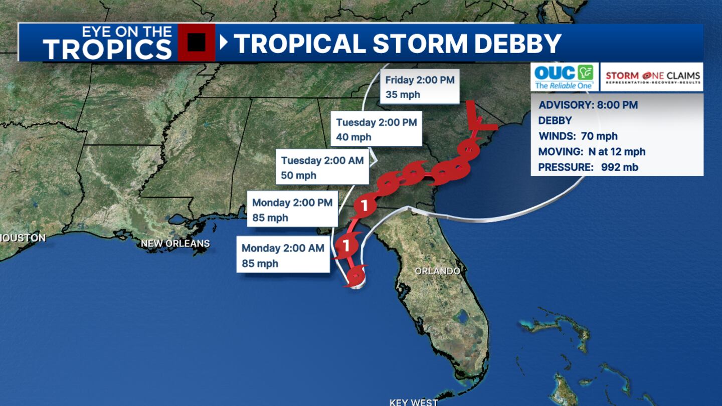
9 p.m. update
Debby’s winds are now up to 70 miles per hour, and the powerful tropical storm has shifted to the northeast.
Chief meteorologist Tom Terry said that Debby will likely be close to Steinhatchee, Florida, before daybreak Monday.
Florida Gov. Ron DeSantis said Sunday that the state has taken steps to limit flooding.
“We have -- at the state level -- constructed more than 9,400 feet of flood protection devices to support critical infrastructure against flooding impacts,” he said.
DeSantis said that the state has set up those flood control barriers around utility substations, helping reduce power outages.
But there are already thousands of people without power from Miami to the Tampa Bay area.
DeSantis said that 3,000 service members of the Florida National Guard are on standby.
Florida has received approval for a federal disaster declaration.
Tropical Storm Debby: Longwood neighborhood sees more standing water Channel 9 visited Shadowbay in Seminole County, where neighbors are seeing more standing water as rain falls. (WFTV)
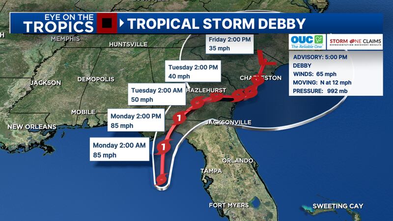
5 p.m. update
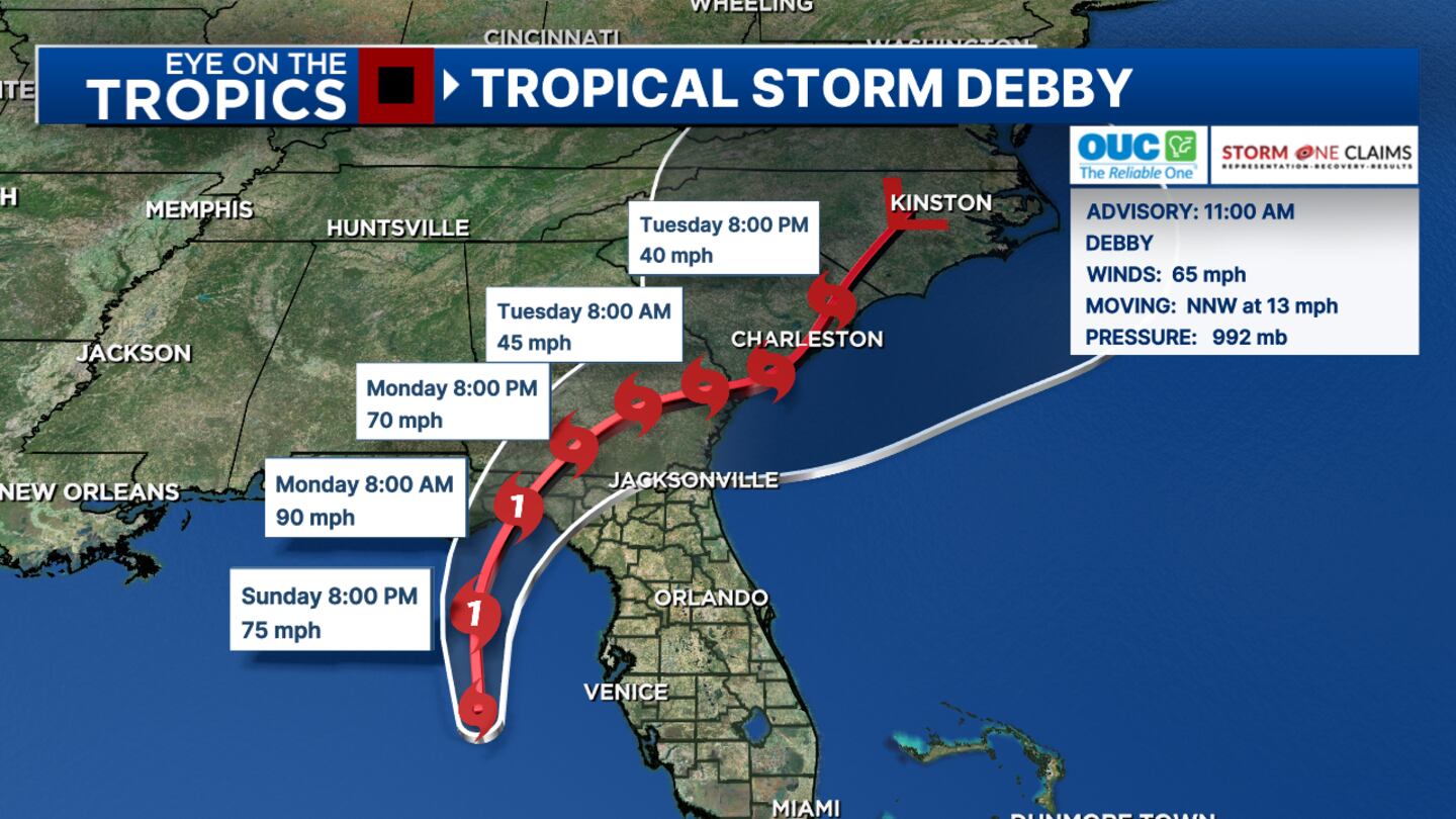
Debby is expected to become a hurricane Sunday evening, making landfall in Florida’s Big Bend area Monday.
The tropical storm will bring a major flood threat to the southeastern United States.
Certified meteorologist George Waldenberger said that the storm has not strengthened since this morning, but another Hurricane Hunter mission will determine if the storm is strengthening Sunday evening as expected.
“Debby is expected to become a hurricane tonight, with landfall as a high-end Category 1 tomorrow,” he said. “However, a Category 2 cannot be ruled out.”
The storm is moving north at 12 miles per hour.
Its maximum sustained winds are 65 miles per hour.
Click here to see live updates about Debby on Channel 9 Eyewitness News, and see the storm’s latest track below:
Tropical Storm Debby: See the 5 p.m. update Tropical Storm Debby is closing in on Florida. Watch Channel 9 Eyewitness News for the latest updates on its effects. (WFTV)
4:30 p.m. update
The University of Florida said that it will close its main campus in Gainesville on Monday because of Tropical Storm Debby, which is forecast to make landfall as a Category 1 hurricane.
The school said that classes are canceled Monday -- both in-person and online -- as well as all academic and student-related activities and exams.
The university will announce Monday its plans to resume classes and normal campus operations.
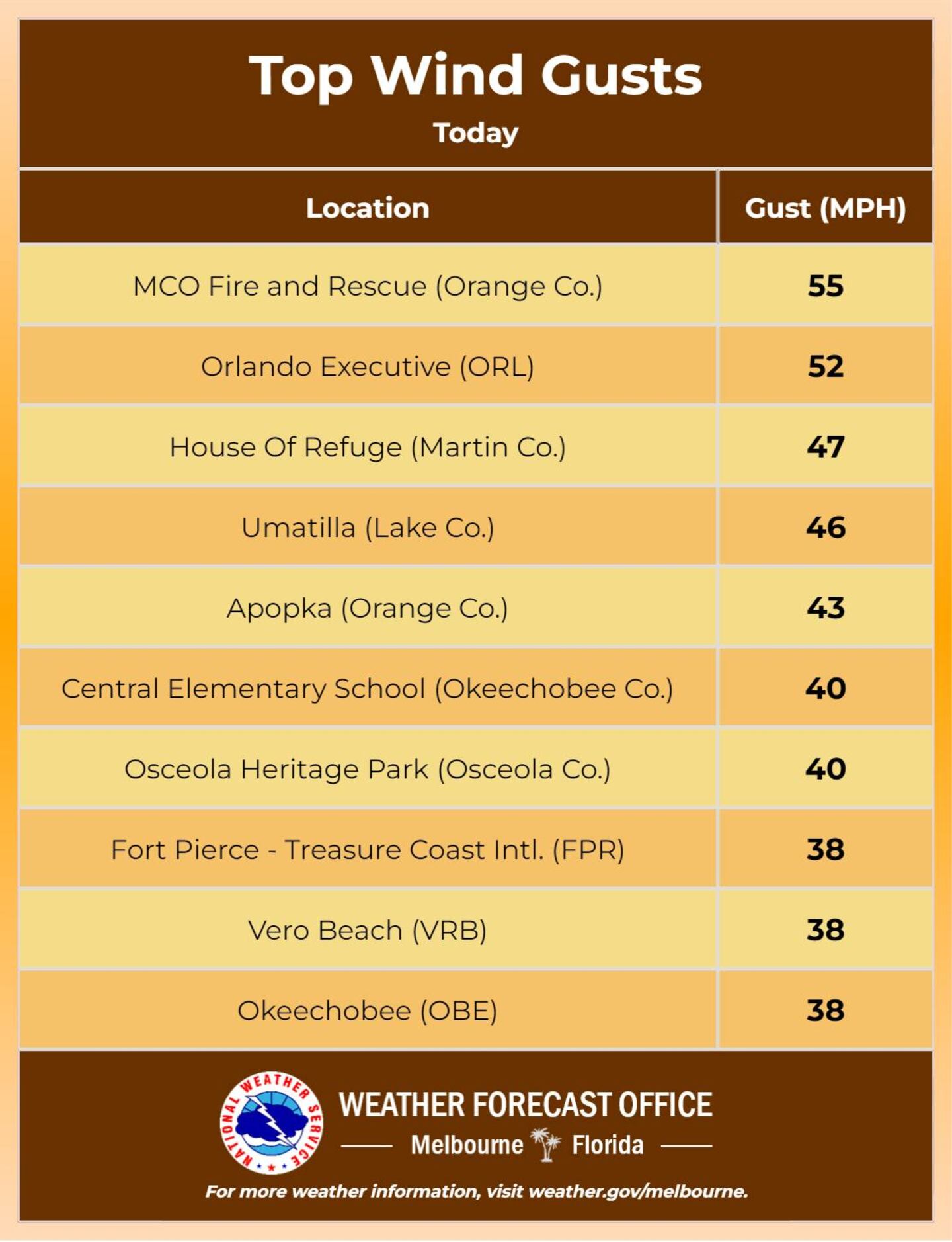
The U.S. National Weather Service released a graphic illustrating the top wind gusts from across Central Florida. See it below.
NWS said many of the observations have occurred as a result of gusty rain bands and embedded storms.
Sunday's top wind gusts in Central Florida The United States National Weather Service shared Central Florida's top wind gusts Sunday as Tropical Storm Debby neared Florida. (WFTV)
Tropical Storm Debby: Expected to become a hurricane by this evening (WFTV)
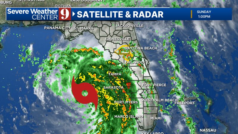
2: 27 p.m. update
60MPH wind gusts possible with stronger cell passing Sanford, Lake Jessup, Geneva, Lake Harney areas. Severe t-storm warning Seminole/Volusia Co. until 230pm. More quick warnings like this through the afternoon. pic.twitter.com/KbGRUokbmy
The storm is forecast to become a hurricane by this evening.
Outer bands are kicking up strong gusty squally showers that will continue off and on this afternoon.
Storms may become more frequent and a little stronger tonight.
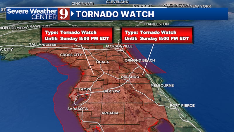
Tornado watch still in effect through 8 p.m.
Flooding risk will progress tonight into tomorrow morning.
Tropical Storm #Debby Advisory 9A: Debby Expected to Strengthen Rapidly Into a Hurricane Before Making Landfall in the Big Bend Area of Florida. Major Flood Threat For the Southeastern United States. https://t.co/tW4KeGe9uJ
— National Hurricane Center (@NHC_Atlantic) August 4, 2024
1:36 p.m. update
A Tornado Warning has been issued to Southwestern of Polk County.
12:50 p.m. update
Severe Thunderstorm Warning has been issued for Apopka, Winter Garden and Leesburg.
12: 49 p.m. update
According to Flagler County Emergency Management, Tropical Strom Debby is will bring 3 to 6 inches of rain.
Wind is expected to be at 15 to 25 miles per hour with gust up to 40.
Tracking Tropical Storm Debby (WFTV)
12:33 p.m. update
Certified Meteorologist Brian Shields said Tropical Storm Debby’s outer bands is making its way through Osceola and Orange County.
12:30 p.m. update
According to National Weather Service Melbourne, there is no major changes to local impacts in Brevard County.
Brevard County will see heavy rainfall leading to flooding and wind gusts to tropical storm force being the primary concerns.
11:02 a.m. update
A Tornado Watch is now up for Central Florida. The threat for isolated tornadoes will be higher for this afternoon, tonight, into tomorrow morning.
Tornado Watch for the following counties:
Flagler
Lake
Marion
Orange
Osceola
Polk
Seminole
Sumter
Volusia
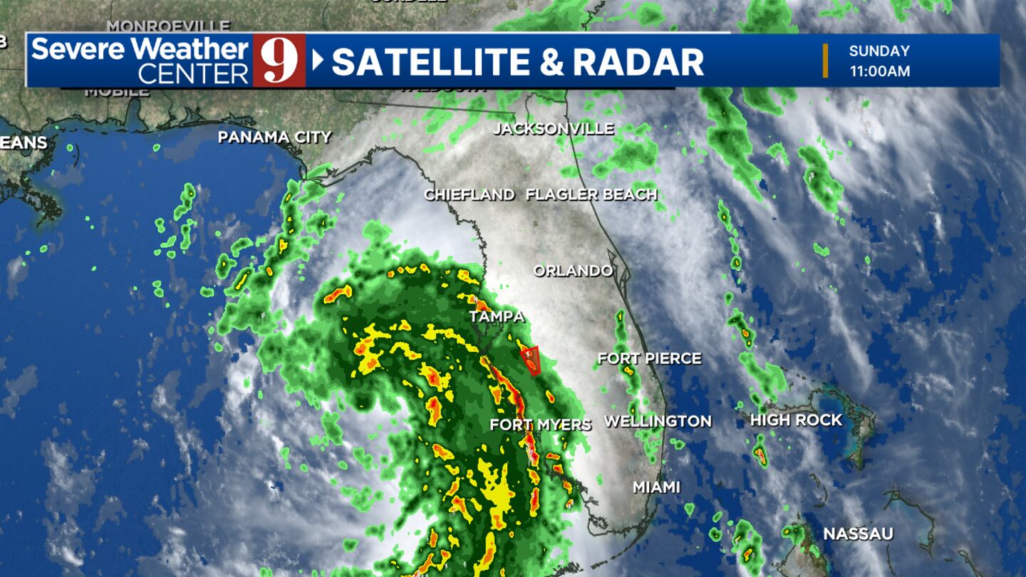
11 a.m. update
Debby continues to strengthen.
Winds are now at 65 mph and it should reach hurricane strength tonight.
Tropical Storm #Debby Advisory 9: Debby Likely to Strengthen Rapidly Before Landfall in The Florida Big Bend Region. Major Flood Threat Looms Over the Southeastern United States. https://t.co/tW4KeGe9uJ
— National Hurricane Center (@NHC_Atlantic) August 4, 2024
TS Debby
TS Debby
9:30 a.m. update
As expected, Debby is strengthening and may become a strong Cat1, even a Cat2 by landfall on Monday morning.
There’s also a ‘slight’ chance for it to get even stronger, but Channel 9 will be monitoring for rapid intensification.
The track is still west of Central Florida, but we’ll have increasing outer squally rain bands and isolated tornado threat Sunday into Monday.
This makes landfall in the Big Bend possibly as a cat2 hurricane, winds over 100mph are possible.
We will have some stronger rain bands in our western zones.
This will be our most active time into the afternoon.
Monday afternoon to Tuesday
With Debby to the north, we’ll see some feeder bands – which will still continue to give us a flood risk and tornado threat. Channel 9 is most concerned about the tornado threat.
Channel 9 meteorologists will continue to monitor the system and provide updates on Eyewitness News.
Follow our Severe Weather team on X for live updates: