ORLANDO, Fla. — Watch Channel 9 Eyewitness News and scroll below for the latest updates on Invest 97L from Channel 9′s team of meteorologists:
9:00 p.m. update
The overall chance for Invest 97L to organize remains at 70%, however; the 48-hour chance is now up 40% - indicating that we are getting closer to the organization of the system.
▶ WATCH CHANNEL 9 EYEWITNESS NEWS
▶ DOWNLOAD NEWS & WEATHER APPS
Conditions haven’t changed much since 2 p.m., with a tropical depression or storm possible by Sunday.
Most models indicate a track to our west.
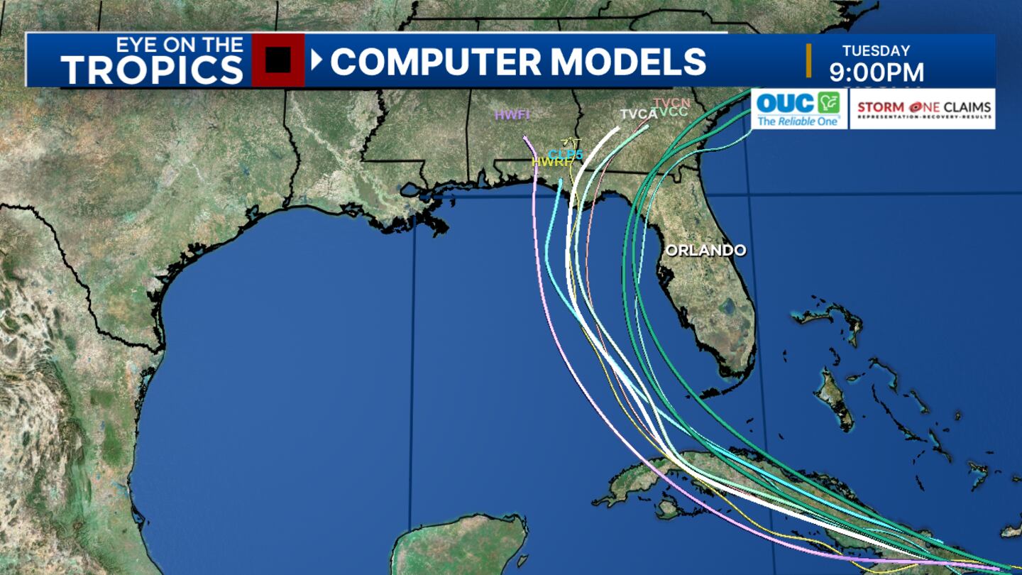
For now, the greatest risk is heavy rain and flooding locally on Sunday inro Monday.
The risk of strong storms and isolated tornados are possible during the same time.
Of course, there still uncertainty in tracking this system as well as the strength of it if it organizes.
5:30 p.m. update
Florida Gov. Ron DeSantis issued an executive order Thursday afternoon, declaring a state of emergency in 54 of the state’s 67 counties ahead of Invest 97L’s potential landfall.
The move marks the first step of executing the state’s emergency management plan, opening the door to allow local emergency management teams to begin operations.
The executive order affects the following counties, including seven of Central Florida’s nine counties:
Read: See where you can get sandbags in Central Florida
Alachua, Baker, Bay, Bradford, Calhoun, Charlotte, Citrus, Clay, Collier, Columbia, Dixie, Duval, Escambia, Flagler, Franklin, Gadsden, Gilchrist, Gulf, Hamilton, Hernando, Hillsborough, Holmes, Jackson, Jefferson, Lafayette, Lake, Lee, Leon, Levy, Liberty, Madison, Manatee, Marion, Monroe, Nassau, Okaloosa, Orange, Osceola, Pasco, Pinellas, Polk, Putnam, Santa Rosa, Sarasota, Seminole, St. Johns, Sumter, Suwannee, Taylor, Union, Volusia, Wakulla, Walton and Washington.
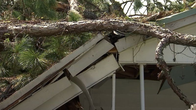
Florida is monitoring Invest 97L in the Atlantic, which is expected to strengthen and potentially make landfall as early as this weekend. It will be slow-moving and bring lots of rain that could cause significant flooding.
— Ron DeSantis (@GovRonDeSantis) August 1, 2024
I encourage all residents to prepare for the storm and…
5 p.m. update
As things heat up in the tropics, governments in Central Florida are helping residents prepare for any potential impacts from a storm.
Some municipalities and counties have begun to offer sandbags to residents.
Click here for a list of sandbag pick up sites in the area, and scroll below for an update on the disturbance.
Click here to download our free news and weather apps. And watch Channel 9 Eyewitness News for the latest updates on this disturbance.

2 p.m. update
Invest 97L now has a 70% chance of development.
It is currently a tropical wave over Hispaniola.
WATCH: ‘Predicting the Path,’ a Severe Weather Center 9 special
Development will likely be slow over the next one to two days.
There is a better chance that it will develop this weekend or early next week, certified meteorologist George Waldenberger said.
“For now, expect a higher chance of heavier rains Sunday, Monday and possibly beyond,” he said. “Strong storms may be possible with this disturbance nearby in the same time frame.”
Photos: What will the 2024 hurricane names be?
Waldenberger said he is still “watching to see where circulation emerges and how organized this system can become by early next week.”
He said a possible stall could stretch out any possible impacts to next week.
The next name on the list of named storms is Debby.
0 of 26


11 a.m. update
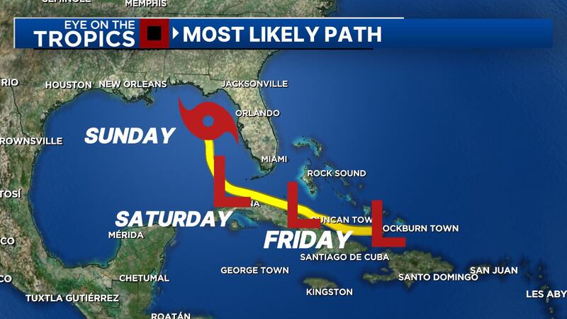
Chief meteorologist Tom Terry said Thursday morning that the newly designated Invest 97L is now over the Dominican Republic and is moving west-northwest toward the Straits of Florida and the eastern Gulf of Mexico early this weekend.
“Water temperatures are in the upper 80s, adding plenty of fuel for this system to grow into Debby -- possibly even a hurricane by late weekend and early next week near our west coast,” he said
Terry said the overnight Global Forecast System predict a storm near the west coast of Florida late this weekend and possibly stalling or slowing near the Big Bend of Florida.
“Heavy rain and worse (is possible) with this scenario for the Sunshine State,” he said.
Earlier story
A tropical disturbance near Puerto Rico continues to become more organized.
The system has a 60% chance of tropical development over the weekend as it moves into the Bahamas.
The disturbance will be near Cuba and South Florida on Saturday.
Read: 9 things you might not know about Orlando
The forecast models have shifted more to the west and show the system moving into the Gulf of Mexico on Sunday.
It could be near the west coast of Florida as a tropical storm early next week.
Watch: Brevard Zoo releases sea turtle Jupiter to the ocean
If that happens, it could mean substantial rain for Florida.
Where the storm will go and how strong it will be is uncertain because dry air has worked against its development.
Read: 9 Investigates Central Florida’s teacher shortage
Channel 9 meteorologists will continue to monitor the system and provide updates on Eyewitness News.
Follow our Severe Weather team on X for live updates:

©2024 Cox Media Group


