ORLANDO, Fla. — Watch Channel 9 Eyewitness News and scroll below for the latest updates on Potential Tropical Cyclone 4 from Channel 9′s team of meteorologists:
▶ WATCH CHANNEL 9 EYEWITNESS NEWS
▶ DOWNLOAD NEWS & WEATHER APPS
12:30 a.m. update
Tropical Depression 4 has formed south of Central Cuba on Friday night.
TD4 is still moving mainly west, and this is making the track shift a bit to the west as well.
Read: LIVE UPDATES: 3 deputies shot at Lake County home
The track timing has also slowed down due to the extra mileage the storm is tracking.
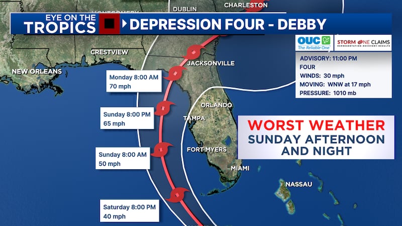
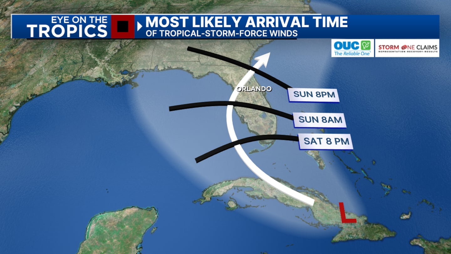
The worst weather will likely be late Sunday afternoon, evening, and overnight along the Interstate 75 corridor, with some outer squalls possible closer to Interstate 4.
Read: 9 Investigates: Family questions how Orange County inmate died in custody
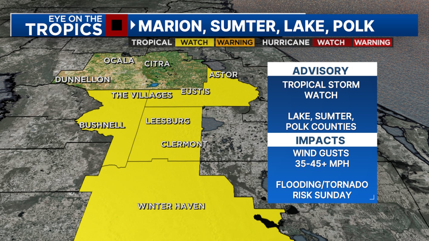
As the storm gets closer to hurricane strength it will have a tendency to pull in the outer bands a bit and will likely keep the worst weather along our Sumter, Lake, Marion counties.
WFTV will keep an eye on Monday for our northern and Flagler counties as the system may emerge off the coast of Georgia and slow down.
11 p.m. update
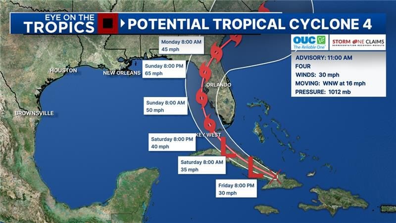
Potential Tropical Cyclone 4 is now officially Tropical Depression 4.
The system is expected to strengthen into Tropical Storm Debby over the eastern Gulf of Mexico sometime Saturday, tracking off the west coast of Florida during the day on Sunday.
Read: See where you can get sandbags in Central Florida
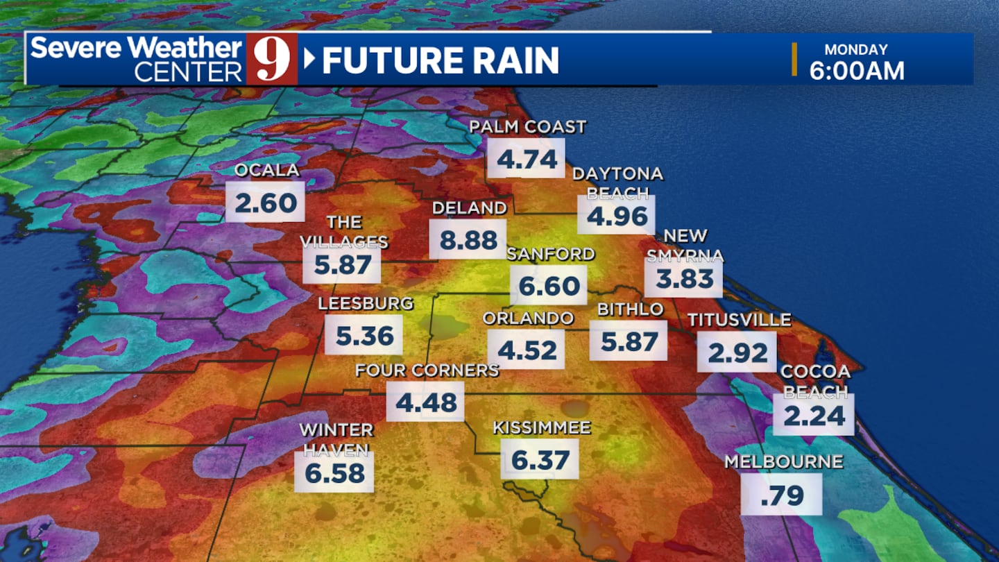
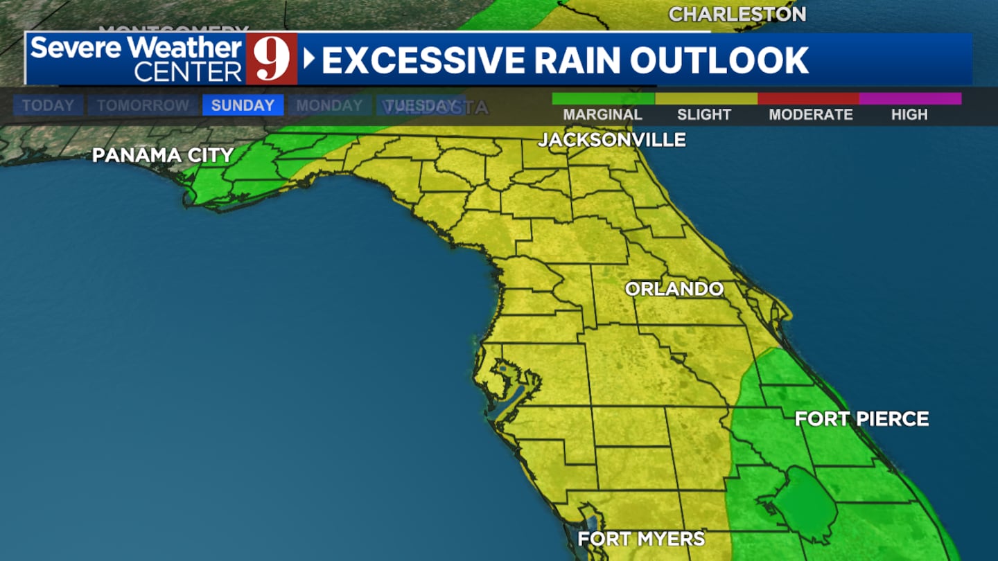
Central Florida will be on the wet and squally side of the system, with heavy rain.
More than four to six inches are expected Sunday afternoon and evening into early Monday.
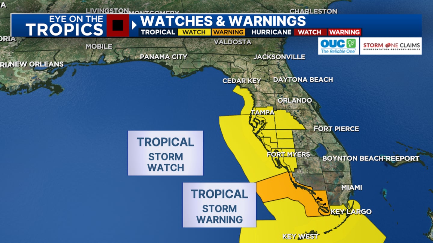
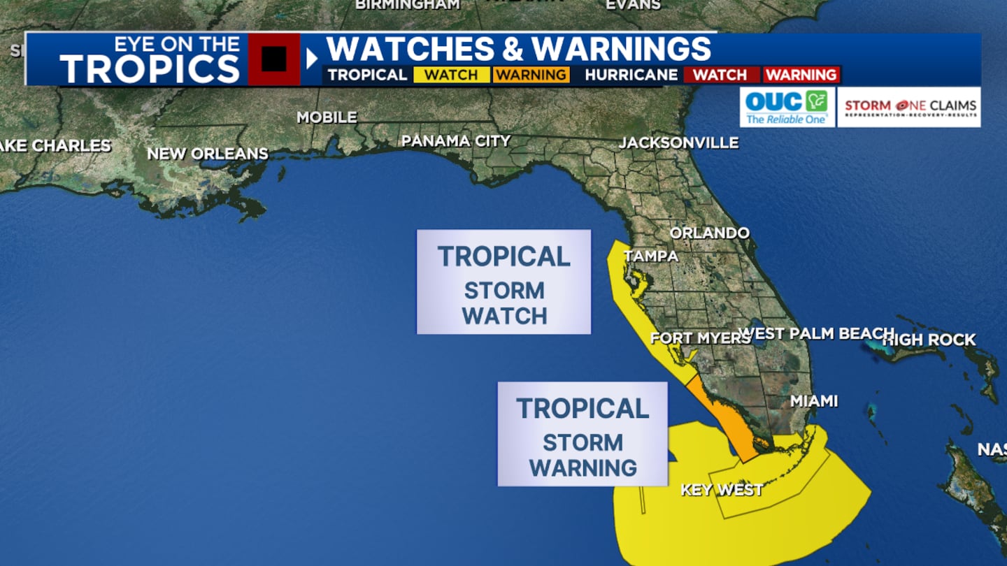
The National Weather Service issued tropical storm watches for Lake, Polk and Sumter counties earlier Friday.
5:45 p.m. update
The National Weather Service on Friday afternoon issued tropical storm watches for Lake, Polk and Sumter counties.
Watch Channel 9 Eyewitness News for changes in the storm’s track.
Read: Firefighter becomes sixth shark bite victim in Volusia County
Disturbance over Cuba still not a tropical depression, but we'll continue getting track updates at 5 and 11 p.m. and a.m. Getting ready for tropical-storm impacts by Sunday, with heaviest rains on the right side of the track. pic.twitter.com/tsljZbSLi4
— George Waldenberger (@GWaldenWFTV) August 2, 2024
5 p.m. update
Chief meteorologist Tom Terry and certified meteorologist George Waldenberger are tracking Potential Tropical Cyclone 4 live in Severe Weather Center 9. They’re providing live updates and in-depth analysis of the system.
Read the National Hurricane Center’s 5 p.m. update below, and watch Channel 9 Eyewitness News for continuing coverage:
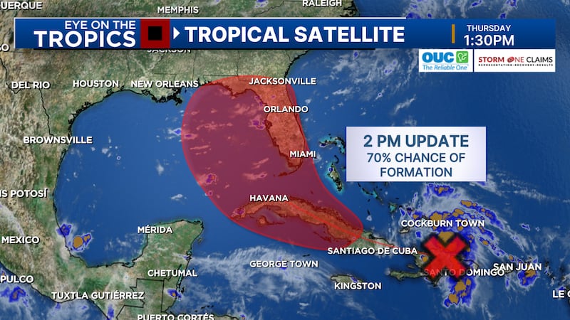
Potential Tropical Cyclone 4 is still disorganized, but it’s showing a little more circular flow and thunderstorm activity over Cuba.
Read: Action 9: How to prepare before the storm
But without a well-defined center, it is still not organized enough to be a tropical depression.
Hurricane Hunters are investigating the north side of the system, the maximum sustained winds of which are 30 miles per hour.
The system is forecast to strengthen into Tropical Storm Debby on Saturday.
See the latest track below:
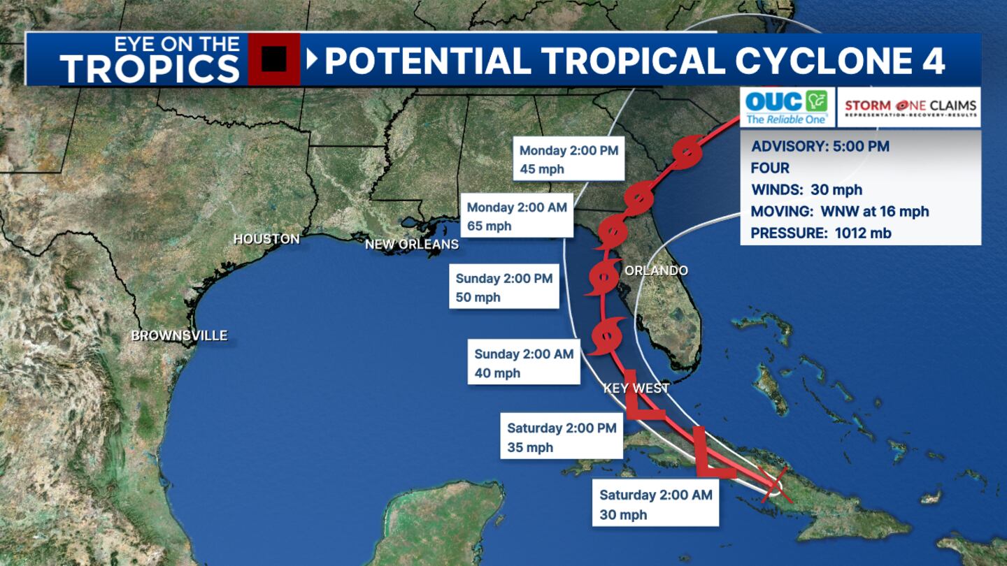
As of 5 p.m., a tropical storm watch has been expanded northward to Florida’s west coast to include Cedar Key.
4:30 p.m. update
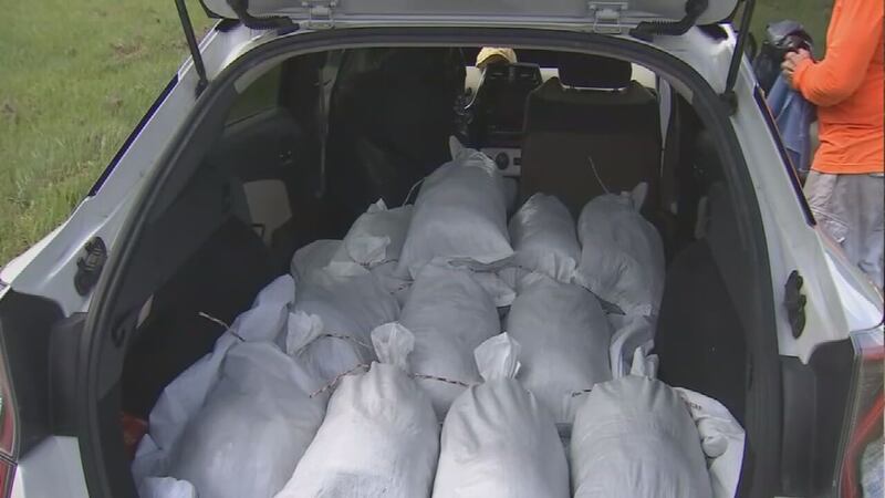
Orange County to offer sandbags at 5 parks
Orange County Public Works said Friday that it will offer self-serve sandbags to residents from 9 a.m. to 5 p.m. Saturday.
Potential Tropical Cyclone 4 is currently in the Caribbean and is forecast to develop into a tropical storm within the next 48 hours.
Read: Hurricane watch vs. warning? Remembering the difference is a piece of pie
The sandbags will be offered at the following Orange County parks:
• West Orange Recreation Center: 309 S West Crown Point Road, Winter Garden, FL 34787)
• Downey Park: 10107 Flowers Avenue, Orlando, FL 32825
• Bithlo Community Park: 18501 Washington Avenue, Orlando, FL 32820
• Meadow Woods Park: 1751 Rhode Island Woods Circle, Orlando, FL 32824
• Clarcona Horse Park: 3535 Damon Road, Apopka, FL 32703
“Due to the storm’s path, Orange County officials will decide on Saturday whether sandbags will also be offered at the same locations on Sunday, with hours yet to be determined,” Orange County Government said in a news release.
Orange County Public Works Roads and Drainage Division will deliver sandbags and sand to meet demand.
Residents will be provided with 10 unfilled sandbags and directed to the sand pile.
They must bring their own shovel to fill the sandbags.
The county said Public Works will monitor conditions Sunday and cease operations if conditions become unsafe.
Those who need special assistance should call 311.
Click here to download our free news and weather apps. And watch Channel 9 Eyewitness News for the latest updates on this disturbance.
3:05 p.m. update
Channel 9′s team of meteorologists will provide you coverage on the system’s latest track, beginning at Channel 9 Eyewitness News at 4.
In the meantime, certified meteorologist George Waldenberger said that 4 to 8 inches of rainfall is possible with a risk of flooding -- even flash flooding -- on the east side of the storm’s track.
Read: See where you can get sandbags in Central Florida
The flooding threat is not as high as it was with Hurricane Ian two years ago, but it will be important to monitor the rainfall forecast as it can still change over the next two days, Waldenberger said.
Some areas will experience tropical storm-force winds through Sunday.
Watch: ‘Predicting the Path,’ a Severe Weather Center 9 special
2:45 p.m. update
Governments in Central Florida are helping residents prepare for impacts from Potential Tropical Cyclone 4.
Municipalities and counties are offering sandbags to residents.
Click here for a list of sandbag pick up sites in the area, and scroll below for an update on the system.
11:30 a.m. update
Parts of Florida’s west coast and the Florida Keys are under Tropical Storm watches and warnings.
The National Hurricane Center is now tracking the tropical disturbance as “Potential Tropical Cyclone Four.”
Photos: Track shows tropical disturbance could impact Central Florida this weekend
1 of 10


PTC4 is not organized yet but has a more defined tracking path.
The storm system is currently over eastern Cuba.
The system could make landfall on Florida’s west coast sometime Sunday evening as a hurricane.
The strength of the storm at landfall will depend on how long it stays out to sea.
Central Florida will likely see tropical storm conditions throughout Sunday as the storm moves through the eastern Gulf of Mexico.
7:45 a.m. update
Tropical storm conditions are likely for us on Sunday.
This area should develop Saturday and then be near the west coast of Florida on Sunday.
Read: Hurricane watch vs. warning? Remembering the difference is a piece of pie
If it swings into the Tampa area or closer to Fort Myers, it may not have time to develop much.
If it stays over water longer and moves into the Big Bend, it could have time to strengthen into a hurricane.
Read: See where you can get sandbags in Central Florida
Either way, Central Florida will likely see tropical storm conditions.
We will have some rain bands working in Sunday morning, with heavier rain bands Sunday afternoon and Sunday night.
Some parts of Central Florida may not get much rain, while others get a lot. It depends on where the heavy rain bands set up.
Flooding is possible in the areas impacted by heavy rain bands, up to 5 inches of rain, along with some gusty winds, and a tornado threat.
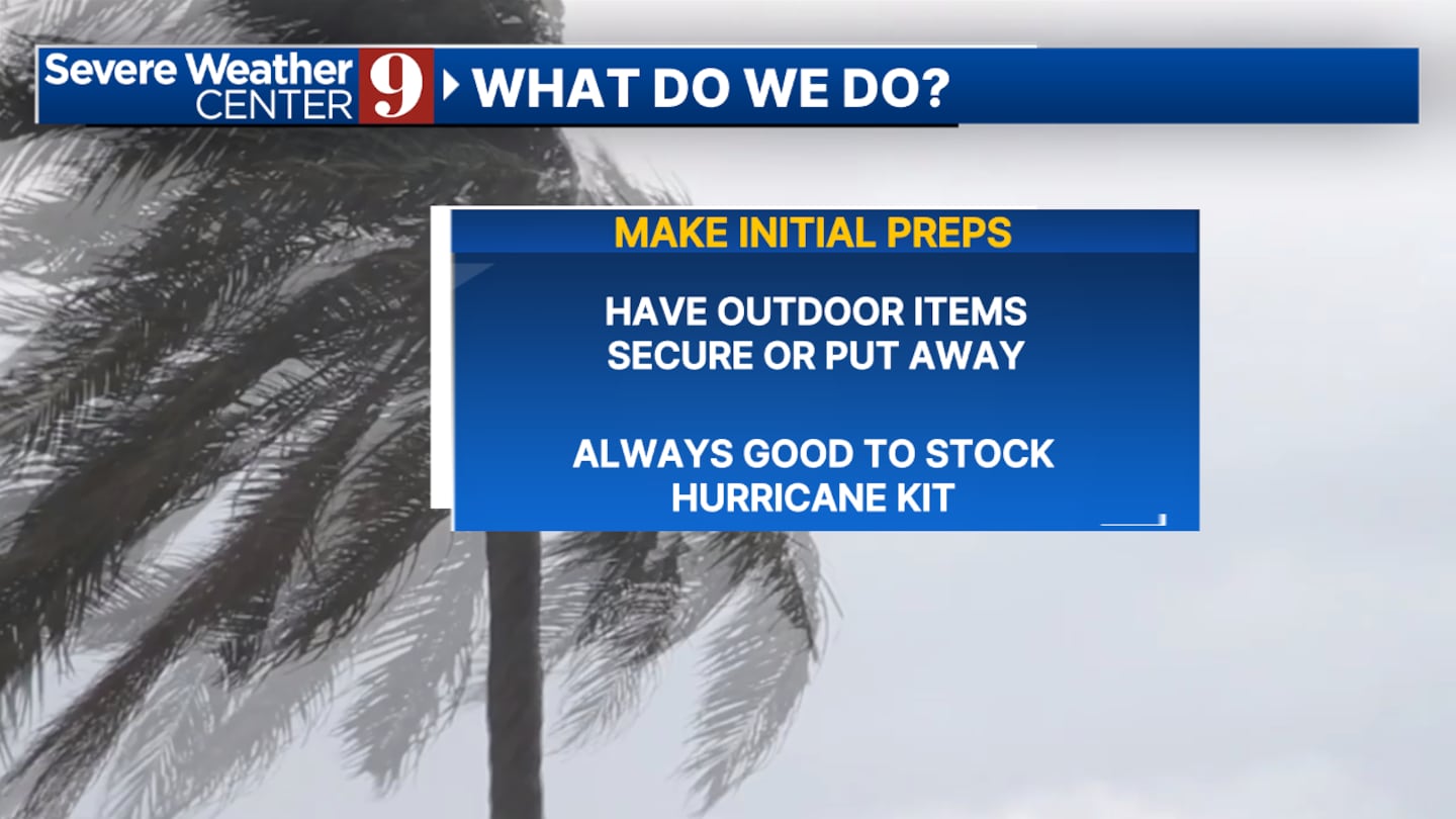
Watch: Action 9: How to prepare before the storm
Resident should secure outdoor items and have their hurricane kits stocked.
Earlier story
The latest forecast data shows that Invest 97L could develop into a named system and impact Florida by Sunday.
Central Florida may see tropical storm conditions on Sunday and Sunday night.
That means some areas don’t get much, while others get stuck in some gusty rain bands, and that could lead to flooding and even some downed branches.
Some parts of Central Florida could see wind gusts over 40 mph and 2 to 5 inches of rain.
Watch: Tracking Invest 97L: DeSantis declares state of emergency in 54 Florida counties
If the system develops into a named storm, it will be called Debby.
1 of 26


The latest track has the system coming onshore anywhere from Tampa up to the Big Bend on Sunday evening, then pulling offshore Monday Morning and moving off the coast of Georgia.
Watch: Central Florida prepares for possible impacts from tropical disturbance
Channel 9 meteorologists will continue to monitor the system and provide updates on Eyewitness News.
Follow our Severe Weather team on X for live updates:

©2024 Cox Media Group