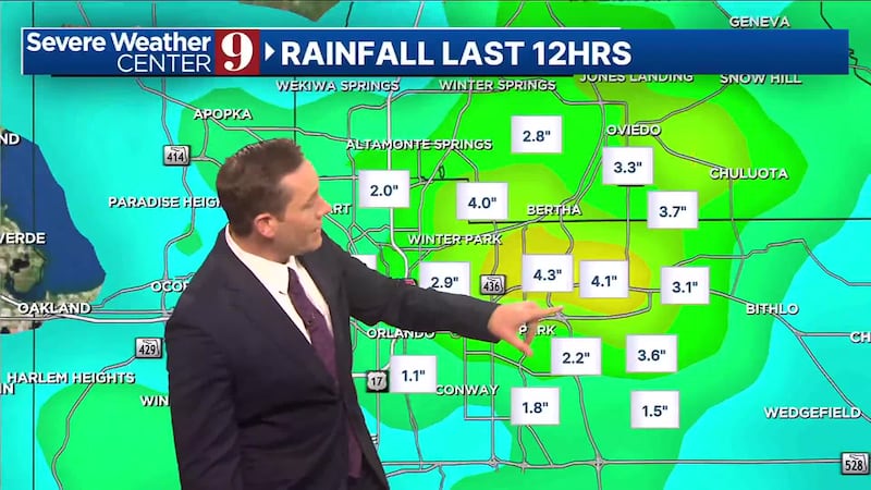
ORLANDO, Fla. — Tornado warning across Central Florida have expired.
8:00 p.m. Update:
However, a flood advisory has been issued for Northeast Orlando, including: Baldwin Park, Winter Park, Maitland, Winter Springs, Goldenrod, Union Park and UCF until p.m.
The tornado warning was issued at 7:15 p.m. for Seminole and Orange counties, including parts of Orlando because of a rotation near Azalea Park.
▶ WATCH CHANNEL 9 EYEWITNESS NEWS
That rotation quickly weakened and expired by 7:30 a.m., but after dropping 2-3 inches of rain.
Storms will gradually taper over the next few hours and should dissipate by 10 p.m.
Storms will continue a weakening trend, but still monitoring in case they can temporarily surge back up. 2-3 inches of rainfall for northeastern Orlando Metro and a flood advisory in place through 10:15pm. pic.twitter.com/2pawbrgPoR
— George Waldenberger (@GWaldenWFTV) June 7, 2024
The heat will continue through the weekend, with spotty showers on Friday and Saturday afternoon.
Next week will be wetter and not as hot.
Read: Boeing’s Starliner spacecraft docks at ISS after concerns over helium leaks
7:20 p.m. update:
A tornado warning has been issued for Orange County and Seminole County.
The warning will be in effect for those areas until 7:45 p.m.
Watch Channel 9 for more details.
Update:
Thursday was the hottest day of 2024 so far.
But strong storms are possible for the area through 8 p.m.
Certified meteorologist George Waldenberger said he is watching for pockets of heavy rain, lightning and the risk for hail and damaging winds.
Read: 4th suspect arrested in deadly Seminole County carjacking
“Despite some beneficial rain falling, not everyone will get rain, and we’ll dry back out with a continuing fire threat for the weekend,” he said. “Record heat is possible through the weekend with daily heat indices exceeding 100 degrees.”
Central Florida will have a better chance for more beneficial rain next week, and you can expect far less heat.
Watch live updates to the forecast on Channel 9 Eyewitness News.
Photos: D-Day invasion 80th anniversary
We just hit 100° in Sanford (heat index: 106°).
— George Waldenberger (@GWaldenWFTV) June 6, 2024
For perspective, 100° is rare here in Central Florida, most years we stay below because of the sea breezes and typical afternoon storms. pic.twitter.com/8TotAIHxsh
Earlier story:
Central Florida will be very hot on Thursday, with a better chance of seeing rain and storms.
▶ WATCH CHANNEL 9 EYEWITNESS NEWS
The high temperature in Orlando should reach around 97 degrees on Thursday afternoon.
Our area will also have a 50% chance of seeing rain and storms in the afternoon.
Some of the storms could be strong.
We will also have a chance to see rain and storm activity on Friday.
Read: Popular West Coast food chain to expand to Florida, including Orlando
The hot weather pattern will stick around for the rest of the week, with highs in the mid-to upper-90s.
Our weekend is looking to be sunny and very hot, with highs near 100 degrees on Saturday and Sunday.
Read: Rock the Country: Ocala country music festival headlined by Kid Rock, Jason Aldean
Thankfully, our tropics remain quiet, but there are several tropical waves being tracked by the National Hurricane Center.
Follow our Severe Weather team on X for live updates:
©2024 Cox Media Group


