ORLANDO, Fla. — It’s feeling warmer today, with a few isolated showers or storms possible this evening.
Update 10:30 p.m.:
Spotty rain from Wednesday evening is falling apart, but new storms are possible on Thursday afternoon.
Strong isolated storms, with heavy rain are possible.
While we need rain, the scattered nature of tomorrow’s storms will mean not all of us get it.
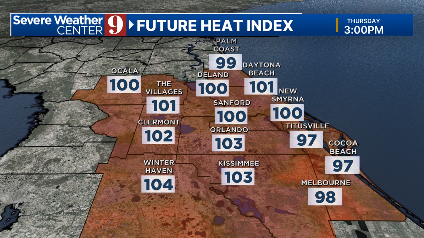
Meanwhile, expect four hot days ahead, record heat possible this weekend with a 100+ heat index each of the next four days.
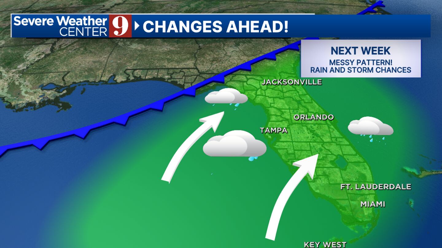
Next week looks wetter and not as hot.
Original Story:
Certified meteorologist George Waldenberger said a few areas could get brief downpours during dinner or bedtime while other areas will stay mostly dry.
Tomorrow, it’s hotter yet, with 100+ heat index numbers.
That is before the best chance of rain in a while.
Read: Popular West Coast food chain to expand to Florida, including Orlando
Isolated storms could be on the horizon with heat Tomorrow, it’s hotter yet, with 100+ heat index numbers. (George Waldenberger/WFTV)
Tomorrow afternoon, scattered rains and storms may occur, and there’s even a risk of hail.
With the nature of tomorrow’s rain, some areas could get soaked while others stay dry.
Read: Disney, oversight district agree to 5th major park, 2 minor parks, 14,000 more hotel rooms, more
We heat up to near records this weekend with drier conditions.
And a potentially wet next week with the assistance of tropical moisture.
Isolated storms could be on the horizon with heat (George Waldenberger/WFTV)
Read: Saigon Night Market debuts in Orlando this weekend
Follow our Severe Weather team on X for live updates:
Click here to download our free news, weather and smart TV apps. And click here to stream Channel 9 Eyewitness News live.
2024 hurricane names (YinYang/iStock) 2024 hurricane names (YinYang/iStock) 2024 hurricane names (YinYang/iStock) 2024 hurricane names (YinYang/iStock) 2024 hurricane names (YinYang/iStock) 2024 hurricane names (YinYang/iStock) 2024 hurricane names (YinYang/iStock) 2024 hurricane names (YinYang/iStock) 2024 hurricane names (YinYang/iStock) 2024 hurricane names (YinYang/iStock) 2024 hurricane names (YinYang/iStock) 2024 hurricane names (YinYang/iStock) 2024 hurricane names (YinYang/iStock) 2024 hurricane names (YinYang/iStock) 2024 hurricane names (YinYang/iStock) 2024 hurricane names (YinYang/iStock) 2024 hurricane names (YinYang/iStock) 2024 hurricane names (YinYang/iStock) 2024 hurricane names (YinYang/iStock) 2024 hurricane names (YinYang/iStock) 2024 hurricane names (YinYang/iStock) 2024 hurricane names (YinYang/iStock) Hurricane season names These are the names for storms that develop during the 2023 Atlantic hurricane season. (WFTV.com News Staff) Arlene These are the names for storms that develop during the 2023 Atlantic hurricane season. (WFTV.com News Staff) Bret These are the names for storms that develop during the 2023 Atlantic hurricane season. (WFTV.com News Staff) Cindy These are the names for storms that develop during the 2023 Atlantic hurricane season. (WFTV.com News Staff) Don These are the names for storms that develop during the 2023 Atlantic hurricane season. (WFTV.com News Staff) Emily These are the names for storms that develop during the 2023 Atlantic hurricane season. (WFTV.com News Staff) Franklin These are the names for storms that develop during the 2023 Atlantic hurricane season. (WFTV.com News Staff) Gert These are the names for storms that develop during the 2023 Atlantic hurricane season. (WFTV.com News Staff) Harold These are the names for storms that develop during the 2023 Atlantic hurricane season. (WFTV.com News Staff) Idalia These are the names for storms that develop during the 2023 Atlantic hurricane season. (WFTV.com News Staff) Jose These are the names for storms that develop during the 2023 Atlantic hurricane season. (WFTV.com News Staff) Katia These are the names for storms that develop during the 2023 Atlantic hurricane season. (WFTV.com News Staff) Lee These are the names for storms that develop during the 2023 Atlantic hurricane season. (WFTV.com News Staff) Margot These are the names for storms that develop during the 2023 Atlantic hurricane season. (WFTV.com News Staff) Nigel These are the names for storms that develop during the 2023 Atlantic hurricane season. (WFTV.com News Staff) Ophelia These are the names for storms that develop during the 2023 Atlantic hurricane season. (WFTV.com News Staff) Philippe These are the names for storms that develop during the 2023 Atlantic hurricane season. (WFTV.com News Staff) Rina These are the names for storms that develop during the 2023 Atlantic hurricane season. (WFTV.com News Staff) Sean These are the names for storms that develop during the 2023 Atlantic hurricane season. (WFTV.com News Staff) Tammy These are the names for storms that develop during the 2023 Atlantic hurricane season. (WFTV.com News Staff) Vince These are the names for storms that develop during the 2023 Atlantic hurricane season. (WFTV.com News Staff) Whitney These are the names for storms that develop during the 2023 Atlantic hurricane season. (WFTV.com News Staff) ©2024 Cox Media Group