ORLANDO, Fla. — Millions of people in Florida are preparing for the impact of Hurricane Milton.
Click here for the newest live updates on Milton.
▶ WATCH CHANNEL 9 EYEWITNESS NEWS

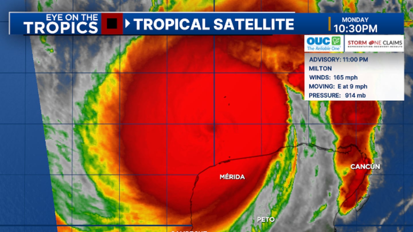
11 p.m. update:
Hurricane Milton is maintaining a Cat. 5 status with slightly weaker winds.
The 11 p.m. advisory from the National Hurricane Center has winds of 165 mph, showing some slight weakening.
Earlier today, Milton recorded a central pressure of 987 mb, making it one of the strongest hurricanes in the Gulf on record.
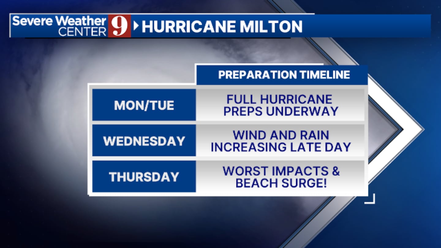
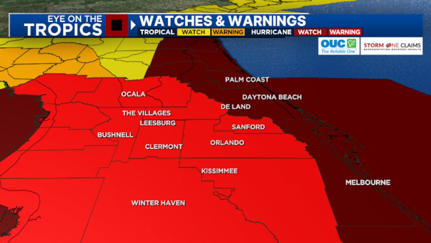
Hurricane Warnings continue for most of Central Florida, including Metro Orlando, and Hurricane Watches are in effect for Brevard, Volusia, and Flagler counties. Hurricane-force winds are expected area-wide late Wednesday into Thursday.
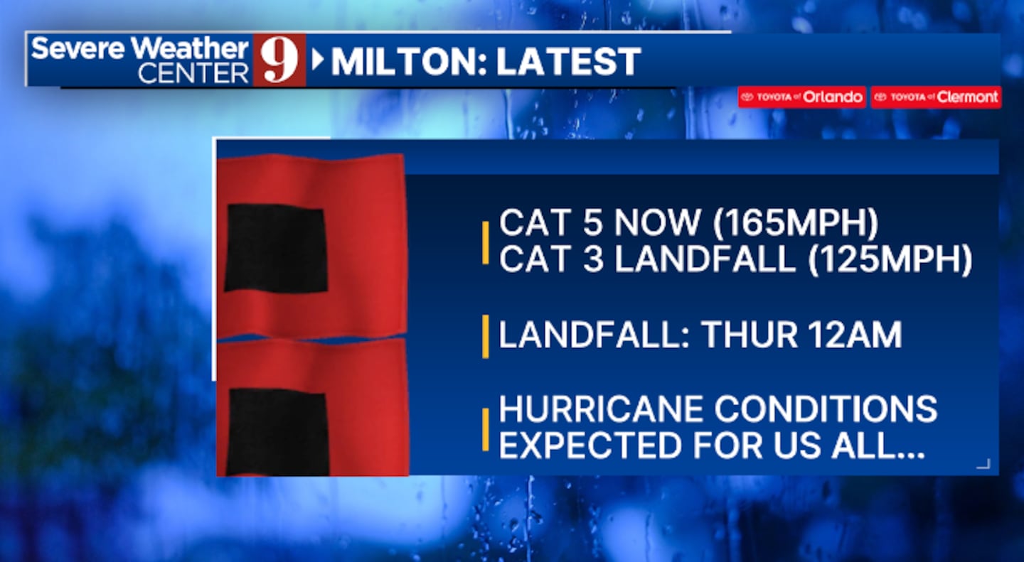
Milton is expected to maintain its Category 5 strength through Tuesday, then weaken some as it nears Florida. It is expected to remain a major hurricane at landfall.

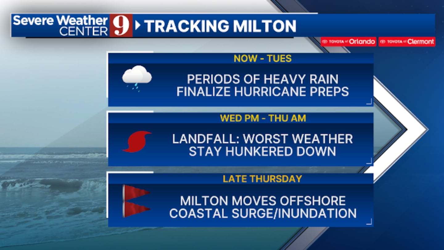
The latest track shows Milton making landfall along the west coast of Florida early Thursday morning. It is then expected to track across Central Florida on Thursday.
The threat of a major hurricane strike is now becoming likely across the west coast of Florida. A catastrophic storm surge and hurricane-force winds are possible along and south of the landfall point.
In Central Florida, the threat for significant impacts continues to increase. Hurricane-force winds over 74 mph, rainfall over 10 inches and storm surge along the east coast of 3-5 feet are all possible.
Stay with Channel 9 for updates on Milton.
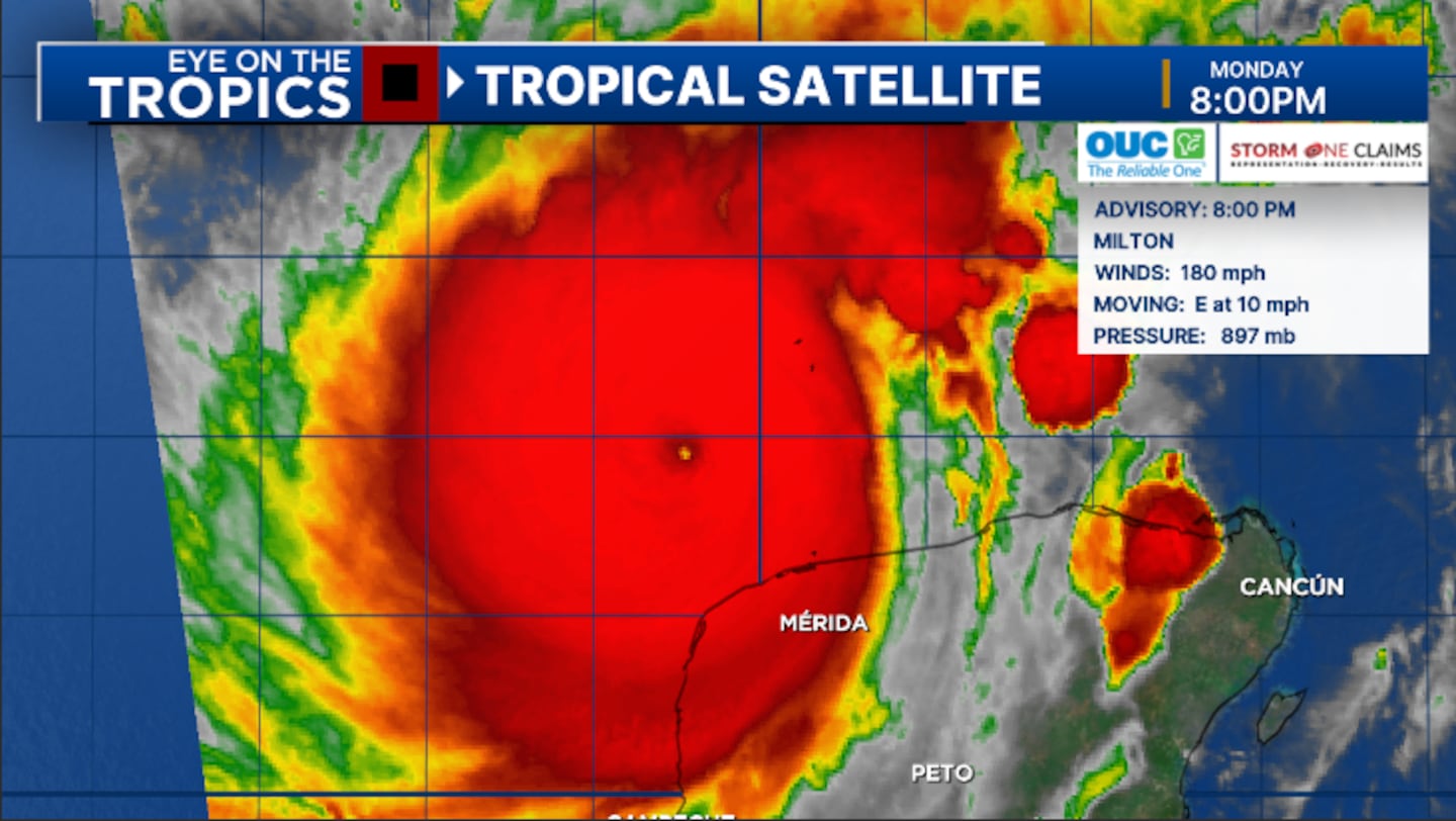
8 p.m. update:
Milton remains a powerful Category 5 major hurricane and shows signs of further intensification tonight.
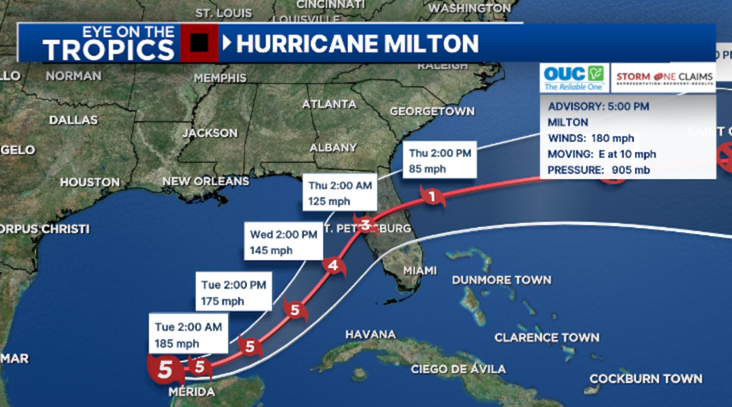
The 5 p.m. advisory from the National Hurricane Center has winds of 180 mph, making Milton an intense Category 5 major hurricane.
Hurricane Hunters have found pressures of 897 mb, one of the lowest pressures ever recorded in a Gulf hurricane. Milton’s winds may increase further later tonight.
Hurricane Warnings continue for the majority of Central Florida, including Metro Orlando. This means sustained winds of 74 mph or greater are expected in the next 36 hours.
Hurricane Watches are posted for Brevard, Volusia, and Flagler counties. This means hurricane-force winds are expected in the next 48 hours.
Milton is expected to maintain its Category 5 strength the next 24 hours, then weaken some as it nears Florida. It is expected to remain a major hurricane at landfall.
The updated track now shows Milton making landfall along the west coast of Florida early Thursday morning. It is then expected to track across Central Florida on Thursday.
The threat of a major hurricane strike continues to increase across the west coast of Florida. A catastrophic storm surge and hurricane-force winds are possible along and south of the landfall point.
The threat of significant impacts in Central Florida is also increasing. Hurricane-force winds over 74 mph, rainfall over 10 inches, and a storm surge along the east coast of 3-5 feet are all possible.
Stay with Channel 9 for updates on Milton.
6:30 p.m. update:
Volusia County is enacting a mandatory curfew for residents starting at 8 p.m. Wednesday, Oct. 9., and lasting until 8 a.m. Thursday, Oct. 10, to help traffic during the storm.
Volusia County has also enacted an evacuation order for Hurricane Milton beginning at 8 a.m. Wednesday, Oct. 9 for all areas east of the intracoastal waterway, all manufactured and mobile homes, all low-lying areas and other areas prone to flooding and all campsites and RV recreational parks.
5:45 p.m. update:
Milton continues to intensify as a powerful Category 5 major hurricane, with Hurricane Warnings now posted for much of Central Florida.
The 5 p.m. advisory from the National Hurricane Center has winds of 180 mph, making Milton an intense Category 5 major hurricane.
Tracking Milton: These schools have announced closures
Hurricane Warnings are now in effect for the majority of Central Florida, including Metro Orlando. This means sustained winds of 74 mph or greater are expected in the next 36 hours.
Hurricane Watches are now posted for Brevard, Volusia and Flagler counties. This means hurricane force winds are expected in the next 48 hours.
Milton is expected to maintain its Category 5 strength the next 24 hours, then weaken some as it nears Florida. It is expected to remain a major hurricane at landfall.
Read: Hurricane safety: 16 tips that could save your life during a storm
The updated track now shows Milton making landfall along the west coast of Florida early Thursday morning. It is then expected to track across Central Florida Thursday.
The threat of a major hurricane strike continues to increase across the west coast of Florida. Catastrophic storm surge is possible along and south of the landfall point, along with hurricane-force winds.
In Central Florida, the threat for significant impacts is also increasing. Hurricane-force winds over 74 mph, rainfall over 10 inches and storm surge along the east coast of 3-5 feet are all possible.
Stay with Channel 9 for updates on Milton.
5:15 p.m. update
Lake County Schools will close on Tuesday, Wednesday, and Thursday.
Osceola Schools will close Tuesday through Thursday.
Tracking Milton: These schools have announced closures
Marion County has announced a mandatory evacuation for mobile homes, modular-type homes, and RVs, including structures where residents feel unsafe.
It goes into effect on Tuesday at 6 p.m.
Emergency responders will not be going into those locations until it is safe to do so.
Residents are encouraged to seek shelter with family or friends.
There are also Marion County shelters open for them to use.
Hurricane Milton: These shelters are open in Central Florida
5 p.m. update:
Milton continues to rapidly intensify with winds now of 180 mph. It remains a powerful Category 5 major hurricane.
Hurricane Warnings are now in effect for the west coast of Florida, and Hurricane Watches are posted for Brevard, Volusia and Flagler counties.

4:25 p.m. update:
9 Family Connection and WFTV partnered with the Heart of Florida United Way to answer your non-emergency questions during Hurricane Milton. The United Way team is ready to help you.
211 can be reached via phone, text ( text your zip code to 898211) or chat and can help answer any storm-related questions you have about shelters, evacuations and more.
The 211 Information and Referral line is a free and confidential service that connects people to essential health and human services.
A 211 call specialist will connect you with existing resources at local organizations that provide critical services.
Read more about the services being offered here: Have storm-related questions? Call the Hurricane Help Line
4:18 p.m. update:
Volusia County Schools said Gov. Ron DeSantis misspoke in his news conference for school closures, and Volusia County Schools will not be closed on Tuesday.
The school district said the earlier plan is still as follows: early release on Tuesday and schools closed on Wednesday and Thursday.
Tracking Milton: These schools have announced closures
3:35 p.m. update:
Officials with Publix Supermarkets said the grocery store chain is “laser-focused” on serving local communities.
Publix said Monday afternoon that all stores are currently open.
Read: Hurricane safety: 16 tips that could save your life during a storm
“Our manufacturing and distribution teams are working around the clock to make, load and deliver product to our stores as long as it is safe to do so,” a Publix spokesperson said.
Publix said most shoppers buy essential items like water, non-perishable food and batteries.
Shoppers can check in advance if a Publix store location is open by visiting www.publix.com/status.
2:45 p.m. update:
Astronauts aboard the International Space Station released a video of Hurricane Milton taken from low-Earth orbit.
NASA released a video showing a view of the powerful Category 5 storm from one of the external cameras of the ISS.
At 10:28 a.m. EDT October 7, the space station flew over Hurricane Milton and external cameras captured views of the category 5 storm, packing winds of 175 miles an hour, moving across the Gulf of Mexico toward the west coast of Florida. pic.twitter.com/MTtdUosiEc
— International Space Station (@Space_Station) October 7, 2024
The video was captured at 10:28 a.m. as the storm moved through the southern Gulf of Mexico near the Yucatan Peninsula.
1:55 p.m. update:
National Hurricane Center said Hurricane Milton “explosively intensified” into a monstrous Category 5 storm.
Milton has maximum sustained winds of around 175 mph and is moving east near the Yucatan Peninsula at 9 mph.
Florida residents need to pay attention to local officials over the likelihood of expanded evacuation orders, especially on the Gulf Coast.
Hurricane #Milton Advisory 10A: Milton Explosively Intensifies With 175-Mph Winds. Residents in Florida Are Urged to Follow the Advice of Local Officials. https://t.co/tW4KeGe9uJ
— National Hurricane Center (@NHC_Atlantic) October 7, 2024
1 p.m. update:
Gov. Ron DeSantis is planning to hold a press conference Monday afternoon.
DeSantis will speak around 3:30 p.m. from the State Emergency Operations Center in Tallahassee.
Read: Gov. DeSantis declares state of emergency in 35 Florida counties for Tropical Storm Milton
The governor will share the latest details on the state’s preparation for Hurricane Milton.
Florida Division of Emergency Management Director Kevin Guthrie, Florida Department of Transportation Secretary Jared Perdue, Florida Department of Highway Safety and Motor Vehicles Director David Kerner, and Major General John D. Haas Adjutant General of Florida will join DeSantis at the event.
12:47 p.m. update:
President Joe Biden approved an Emergency Declaration for Florida on Monday.
The order was issued over the elevated threat from Hurricane Milton and approves federal support from the federal government.
Read: Mayorkas warns FEMA doesn’t have enough funding to last through hurricane season
The measure allows for disaster funding for dozens of counties in Florida, including all of Central Florida.
The Biden administration said John E. Brogan of FEMA has been appointed to coordinate Federal recovery operations in the affected areas.
Photos: Hurricane Milton strengthens en route to Florida
0 of 10


11:57 a.m. update:
The National Hurricane Center confirmed Hurricane Milton has strengthened into a powerful Category 5 storm.
Milton now has maximum sustained winds around 160 mph.
10:55 CDT Monday Update: Milton rapidly intensifies into a category 5 hurricane. Data from a @53rdWRS hurricane hunter aircraft indicate that the maximum sustained winds have increased to 160 mph (250 km/h) with higher gusts. Follow the latest at https://t.co/tW4KeGe9uJ pic.twitter.com/mOxuvGdtu5
— National Hurricane Center (@NHC_Atlantic) October 7, 2024
11:23 a.m. update:
The National Hurricane Center said Hurricane Milton continues to rapidly intensify in the Gulf of Mexico.
Milton strengthened into a Category 2 storm around 5 a.m. and nearly a Category 5 storm around 9 a.m.
Hurricane tips: What you should do to prepare
Hurricane Milton is now producing winds around 155 mph, which is right on the edge of Category 5.
Damaging hurricane-force winds are expected for a large area of western and Central Florida.

Life-threatening storm surges are expected for areas of Florida’s Gulf Coast.
Landfall is currently expected to happen on Wednesday evening.
Read: Hurricane safety: What are hurricane categories and what do they mean?
Much of Florida has also received several inches of rain over the last few days which will increase our chances of flooding.
Channel 9 has live team coverage from around the state, and people are preparing for Hurricane Milton.
Here are the Key Messages for rapidly intensifying category 4 Hurricane #Milton for Monday late morning. The latest advisory is at https://t.co/tW4KeGe9uJ pic.twitter.com/E0ZWmqChgg
— National Hurricane Center (@NHC_Atlantic) October 7, 2024
10:45 a.m. update:
Several counties on Florida’s Gulf Coast have issued partial mandatory evacuation orders.
Hillsborough, Hernando and Sarasota counties issued the orders Monday morning.
In Hillsborough County, the order applies to people in manufactured and mobile homes in Zone A and Zone B starting at 2:30 p.m.
Similar orders were issued in Sarasota County and Hernando County.
Read: Hurricane evacuation: Helpful apps for finding gas, hotel rooms, traffic routes
9:55 a.m. update:
Gov. Ron DeSantis announced Monday morning that toll road fees in the West Coast of Florida and western Central Florida will be suspended starting at 10:30 a.m.
This is done to encourage people in Hurricane Milton’s direct path to head north and east.
Watch DeSantis’ full news conference here:
9:22 a.m. update:
The National Hurricane Center confirmed Hurricane Milton has strengthened into a powerful Category 4 storm.
Milton now has maximum sustained winds of around 150 mph.
The storm is rapidly intensifying as it moves through the southern Gulf of Mexico en route to Florida.
8:05 AM CDT Monday Update: Milton rapidly intensifies into a category 4 hurricane. The maximum sustained winds have now increased to 150 mph (240 km/h) and the minimum pressure has fallen to 940 mb. pic.twitter.com/wlJXbB5lkr
— National Hurricane Center (@NHC_Atlantic) October 7, 2024
8:51 a.m. update:
School districts around Central Florida are keeping parents and students updated on school closures.
Orange County Public Schools said fake social media messages are going around saying schools are closed Monday through Friday.
Orange County schools are still open Monday and officials are still determining when and if schools will close.
Read the latest of school closures around Central Florida here:
Tracking Milton: These schools have announced closures
8:01 a.m. update:
Florida Power & Light said its crews are moving out to pre-position before the arrival of Hurricane Milton.
Utility crews from around the state are preparing for massive damage and outages when Milton makes landfall as a major hurricane this week.
The latest forecast data has Milton directly impacting the Tampa Bay area as a major Cat. 3 hurricane on Wednesday night.
Florida residents are advised to make final preparations for the storm while they can.
7:11 a.m. update:
The National Hurricane Center confirmed Hurricane Milton has strengthened into a major Category 3 storm.
Milton now has maximum sustained winds of around 120 mph.
6:00 AM CDT Monday Update: NOAA Hurricane Hunters find #Milton a major hurricane. The maximum sustained winds have increased to 120 mph (195 km/h). #Milton is now a category 3 hurricane on the Saffir-Simpson Hurricane Wind Scale. https://t.co/tW4KeGe9uJ pic.twitter.com/EYkFxvTozk
— National Hurricane Center (@NHC_Atlantic) October 7, 2024
In Central Florida, Hurricane Watches have been issued for Sumter and Polk counties and will be extended as the storm draws closer.
6:53 a.m. update:
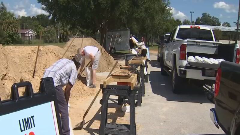
Channel 9 is keeping track of where Central Florida residents can get sandbags ahead of the storm.
As the tropics heat up, governments in Central Florida are helping residents prepare for storm impacts.
Here is a list of the sandbag locations being offered this week ahead of possible storm impacts:
Read: See where you can get sandbags in Central Florida
6:03 a.m. update:
Gov. Ron DeSantis is planning to hold a press conference Monday morning.
DeSantis will speak around 9:30 a.m. from the State Emergency Operations Center in Tallahassee.
Read: Gov. DeSantis declares state of emergency in 35 Florida counties for Tropical Storm Milton
The governor will share the latest details on the state’s preparation for Hurricane Milton.
Florida Division of Emergency Management Director Kevin Guthrie, Florida Department of Transportation Secretary Jared Perdue and Major General John D. Haas Adjutant General of Florida will join DeSantis at the event.
Watch Gov. DeSantis’ full Sunday evening update:
WFTV will have live coverage of DeSantis’ press conference on Channel 9 and wftv.com.
Original report:
Milton continues to intensify and is still on track to be near major hurricane strength at landfall.
The National Hurricane Center confirmed Milton is now a Category 2 hurricane.
Milton is expected to strengthen further and become a Category 3 major hurricane later on Monday and a Category 4 storm on Tuesday.
Read: See where you can get sandbags in Central Florida
There has been a minor change in the forecast. The timing has slowed down.
It now looks like landfall will be along the west coast of Florida on Wednesday night, then tracking across Central Florida overnight Wednesday into early Thursday.
Landfall could still be anywhere from the Nature Coast to the Fort Myers area, but we have seen a slight tick southward in the last 24 hours.
Read: Tracking Milton: These schools have announced closures
The threat continues to increase that Milton will bring significant impacts to parts of the west coast of Florida early next week, including significant storm surge and hurricane-force winds.
It is becoming increasingly likely that Milton will create very significant impacts on parts of the west coast of Florida, including a significant storm surge and hurricane-force winds.
Hurricane Watches and Storm Surge Watches will be needed for parts of the West Coast early Monday morning.
In Central Florida, impacts will be based on the exact track of the storm, but the impact threat continues to increase.

©2024 Cox Media Group


