ORLANDO, Fla. — Eyes remain on the tropics Saturday, as Hurricane Lee continues to move on a WNW path.
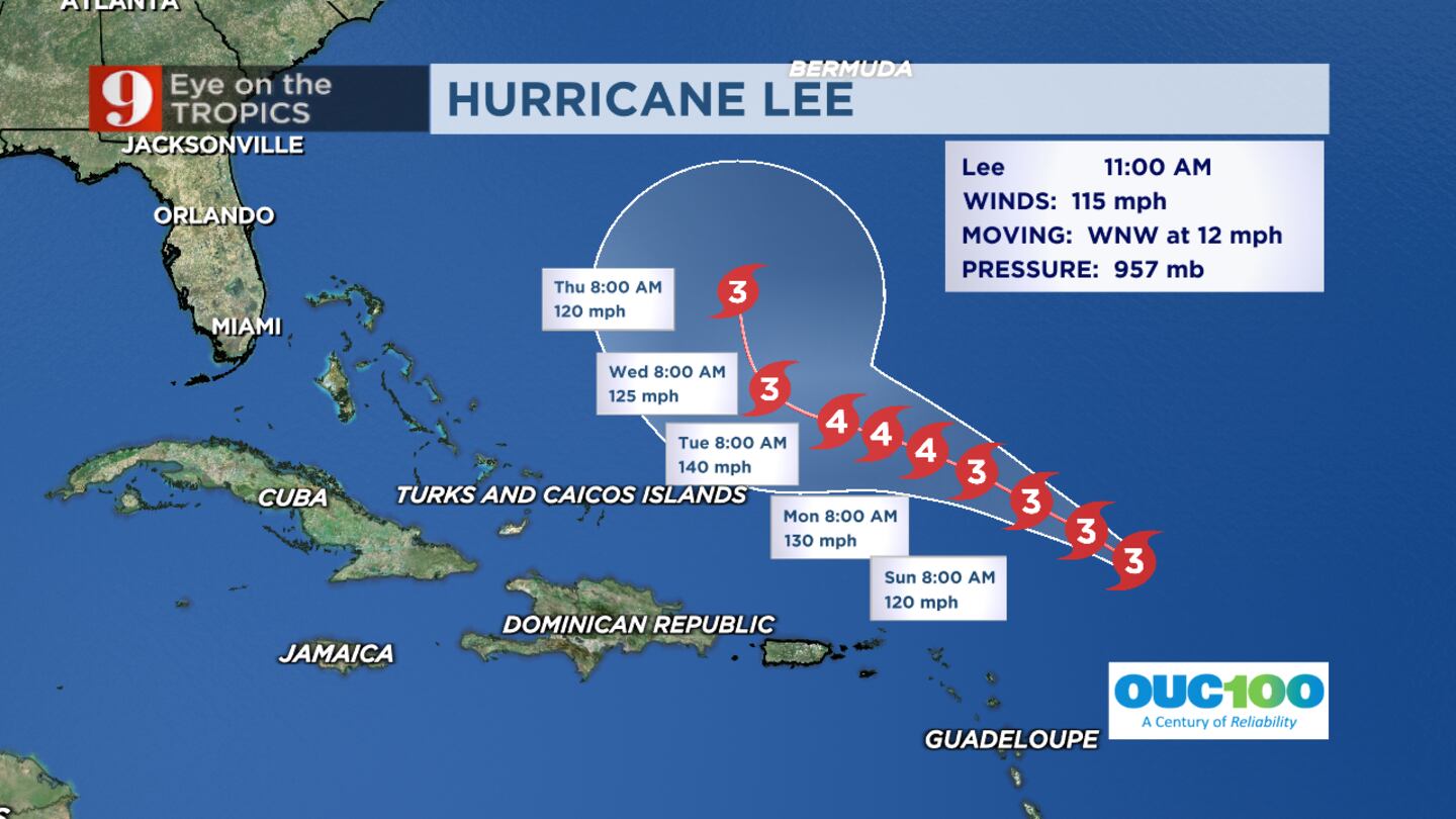
11 a.m. update: Hurricane Lee remains a Category 3 storm with maximum sustained winds at 115 mph, according to the National Hurricane Center.
Hurricane Lee 11 a.m. Saturday track Hurricane Lee remained a Cat 3 storm late Saturday morning. (WFTV Staff)
Lee is expected to slow down and strengthen through the end of the weekend and into early next week, Channel 9 Meteorologist Kassandra Crimi said.
Dangerous surf will continue this weekend for the Leeward Islands, Puerto Rico, Hispaniola, Turks & Caicos, and the Bahamas.
Large waves will eventually make their way onto our Central Florida beach shores. Expect dangerous seas off our coast by the middle of the week.
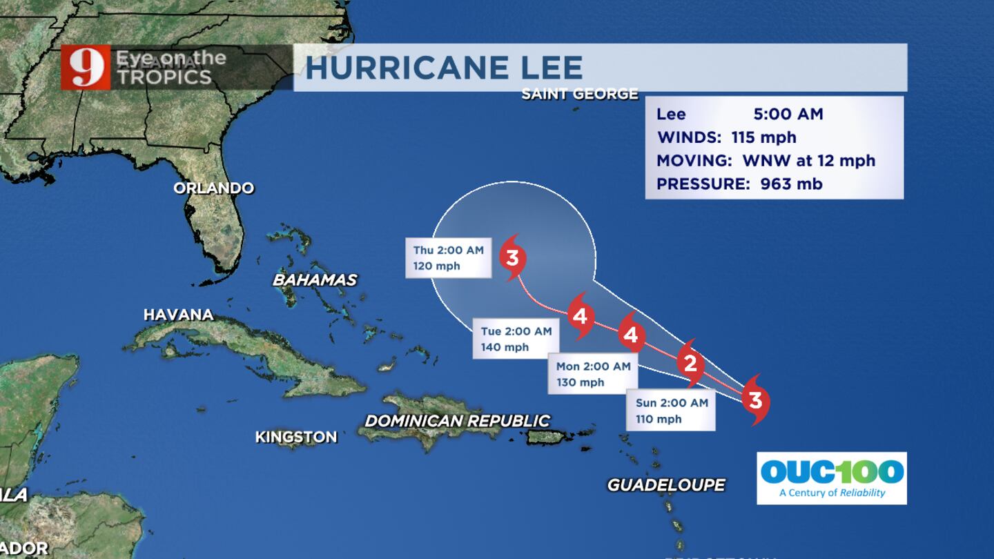
Original Story: Hurricane Lee was downgraded Friday night from Category 4 status to a Category 3 storm and continued to hold that status Saturday morning.
As of the 5 a.m. advisory from the National Hurricane Center, maximum sustained winds were at 115 mph.
READ: ULA scrubs Saturday launch of Atlas V rocket from Space Coast
The storm is expected to stay north of the Eastern Caribbean, with dangerous surf impacting the Leeward Islands on Saturday and spreading to Puerto Rico and Hispaniola on Sunday.
Meteorologist Kassandra Crimi said as we head into next week, Hurricane Lee should be hundreds of miles off our east coast.
WFTV Hurricane Lee Hurricane Lee weakened to a Category 3 storm Friday night. (WFTV Staff)
Nonetheless, the storm will make for dangerous seas on Central Florida’s east coast beaches by mid-week.
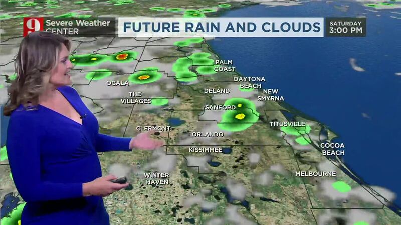
READ: Saturday weather: Morning sunshine, slight chance for afternoon storms in Central Florida
Morning forecast: Saturday, Sept. 9 (Kassandra Crimi, WFTV.com/WFTV)
Channel 9′s meteorologists will continue to monitor the tropics and provide updates on Eyewitness News.
Follow our Severe Weather team on X (Twitter) for live updates:
Hurricane season names These are the names for storms that develop during the 2023 Atlantic hurricane season. (WFTV.com News Staff) Arlene These are the names for storms that develop during the 2023 Atlantic hurricane season. (WFTV.com News Staff) Bret These are the names for storms that develop during the 2023 Atlantic hurricane season. (WFTV.com News Staff) Cindy These are the names for storms that develop during the 2023 Atlantic hurricane season. (WFTV.com News Staff) Don These are the names for storms that develop during the 2023 Atlantic hurricane season. (WFTV.com News Staff) Emily These are the names for storms that develop during the 2023 Atlantic hurricane season. (WFTV.com News Staff) Franklin These are the names for storms that develop during the 2023 Atlantic hurricane season. (WFTV.com News Staff) Gert These are the names for storms that develop during the 2023 Atlantic hurricane season. (WFTV.com News Staff) Harold These are the names for storms that develop during the 2023 Atlantic hurricane season. (WFTV.com News Staff) Idalia These are the names for storms that develop during the 2023 Atlantic hurricane season. (WFTV.com News Staff) Jose These are the names for storms that develop during the 2023 Atlantic hurricane season. (WFTV.com News Staff) Katia These are the names for storms that develop during the 2023 Atlantic hurricane season. (WFTV.com News Staff) Lee These are the names for storms that develop during the 2023 Atlantic hurricane season. (WFTV.com News Staff) Margot These are the names for storms that develop during the 2023 Atlantic hurricane season. (WFTV.com News Staff) Nigel These are the names for storms that develop during the 2023 Atlantic hurricane season. (WFTV.com News Staff) Ophelia These are the names for storms that develop during the 2023 Atlantic hurricane season. (WFTV.com News Staff) Philippe These are the names for storms that develop during the 2023 Atlantic hurricane season. (WFTV.com News Staff) Rina These are the names for storms that develop during the 2023 Atlantic hurricane season. (WFTV.com News Staff) Sean These are the names for storms that develop during the 2023 Atlantic hurricane season. (WFTV.com News Staff) Tammy These are the names for storms that develop during the 2023 Atlantic hurricane season. (WFTV.com News Staff) Vince These are the names for storms that develop during the 2023 Atlantic hurricane season. (WFTV.com News Staff) Whitney These are the names for storms that develop during the 2023 Atlantic hurricane season. (WFTV.com News Staff)
©2023 Cox Media Group