Hurricane Lee intensifies from Category 2 to Category 4 storm; Tropical Storm Margot forms The National Hurricane Center said Thursday afternoon that Hurricane Lee has intensified from a Category 2 storm to a Category 4 storm.
Advisory 11 from the National Hurricane Center said Hurricane Lee is now a Category 5 storm. Dangerous beach conditions are expected to develop around the western Atlantic through early next week.
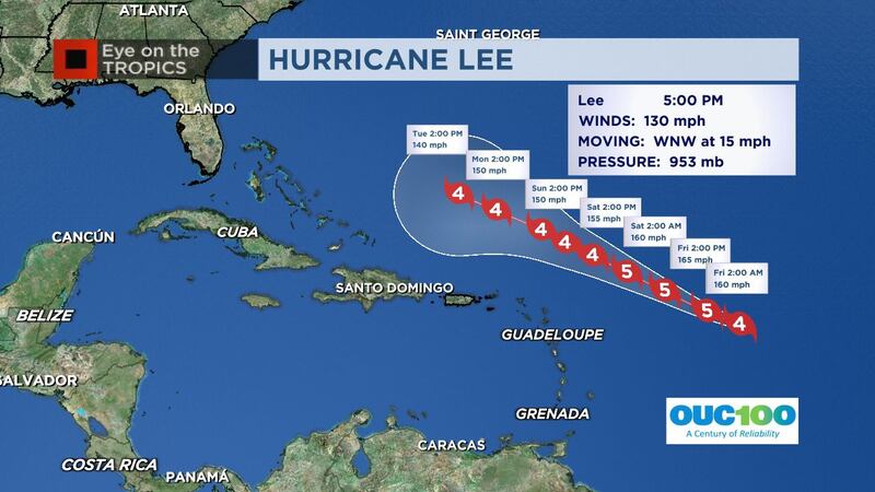
Update: 10:00 p.m.
The National Hurricane Center said Hurricane Lee has strengthened to a strong Category 4 storm and should become a Category 5 overnight.
Chief Meteorologist Tom Terry said the Hurricane Hunter’s second pass showed signs of strengthening, near a Category 5.
Recon finding a very strong #Lee, with winds increasing to high-end Cat 4, near Cat 5. Pressure down substantially from the 5pm advisory to 936mb on the first pass through. A second pass shows near 930mb, a sign of continued strengthening. @WFTVpic.twitter.com/h5JsIizx1V
The National Hurricane Center said Thursday afternoon that Hurricane Lee has intensified from a Category 2 storm to a Category 4 storm.
The agency said rip currents and hazardous surf conditions will spread across the northern Caribbean on Friday and begin affecting the mainland United States by Sunday.
Chief meteorologist Tom Terry said waves from Lee are expected locally by Tuesday and Wednesday and will remain present through next weekend.
“Rough waves are likely to keep the rip current threat very high next week and weekend, and large long-period swells will bring beach erosion potential as well,” he said. “A trough of low pressure along the United States’ east coast next week is expected to turn Lee north and keep the impacts limited to higher waves for us.”
Elsewhere in the Atlantic Ocean, Tropical Storm Margot has also formed.
Cedar Key clean-up Andy Bair hangs a fish outside of his historic Cedar Key hotel after Hurricane Idalia. (Nick Papantonis)
Cedar Key clean-up Cedar Key, Fl was damaged by wind and storm surge during Hurricane Idalia in August, 2023. (Nick Papantonis)
Cedar Key clean-up A lineman fixes a power line damaged during Hurricane Idalia. (Nick Papantonis)
Cedar Key clean-up Mike Hodges stands next to debris piled outside of his family home following Hurricane Idalia in Cedar Key. (Nick Papantonis)
Cedar Key clean-up Cedar Key, Fl was damaged by wind and storm surge during Hurricane Idalia in August, 2023. (Nick Papantonis)
Cedar Key clean-up A sign on a now-washed away beach in Cedar Key, FL following Hurricane Idalia. (Nick Papantonis)
Cedar Key clean-up Leslie Fine looks at damaged buildings in the aftermath of Hurricane Idalia. (Nick Papantonis)
Cedar Key clean-up Cedar Key, Fl was damaged by wind and storm surge during Hurricane Idalia in August, 2023. (Nick Papantonis)
Cedar Key clean-up Cedar Key, Fl was damaged by wind and storm surge during Hurricane Idalia in August, 2023. (Nick Papantonis)
Cedar Key clean-up Cedar Key, Fl was damaged by wind and storm surge during Hurricane Idalia in August, 2023. (Nick Papantonis)
Cedar Key clean-up Cedar Key, Fl was damaged by wind and storm surge during Hurricane Idalia in August, 2023. (Nick Papantonis)
Cedar Key clean-up Two people hug in the aftermath of Hurricane Idalia in Cedar Key, FL. (Nick Papantonis)
Cedar Key clean-up Debris piled on the main street of Cedar Key, FL following Hurricane Idalia in August, 2023. (Nick Papantonis)
Cedar Key clean-up Cedar Key, Fl was damaged by wind and storm surge during Hurricane Idalia in August, 2023. (Nick Papantonis)
Cedar Key clean-up Cedar Key, Fl was damaged by wind and storm surge during Hurricane Idalia in August, 2023. (Nick Papantonis)
Cedar Key clean-up Cedar Key, Fl was damaged by wind and storm surge during Hurricane Idalia in August, 2023. (Nick Papantonis)
Cedar Key clean-up Cedar Key, Fl was damaged by wind and storm surge during Hurricane Idalia in August, 2023. (Nick Papantonis)
Cedar Key clean-up Cedar Key, Fl was damaged by wind and storm surge during Hurricane Idalia in August, 2023. (Nick Papantonis)
Cedar Key clean-up Cedar Key, Fl was damaged by wind and storm surge during Hurricane Idalia in August, 2023. (Nick Papantonis)
Cedar Key clean-up Cedar Key, Fl was damaged by wind and storm surge during Hurricane Idalia in August, 2023. (Nick Papantonis)
Tropical Weather Florida Lorena Torres, left, and Jorge Larancuent clean up debris from Hurricane Idalia Thursday, Aug. 31, 2023, in Cedar Key, Fla. Idalia made landfall early Wednesday morning along Florida's panhandle. (AP Photo/Chris O'Meara) (Chris O'Meara)
Tropical Weather Florida Jorge Larancuent cleans up debris from Hurricane Idalia at the Faraway Inn Thursday, Aug. 31, 2023, in Cedar Key, Fla. Idalia made landfall early Wednesday morning along Florida's panhandle. (AP Photo/Chris O'Meara) (Chris O'Meara)
Tropical Weather Florida The sign to the Faraway Inn is damaged as Jorge Laranacuent cleans up debris from Hurricane Idalia Thursday, Aug. 31, 2023, in Cedar Key, Fla. Idalia made landfall early Wednesday morning along Florida's panhandle. (AP Photo/Chris O'Meara) (Chris O'Meara)
Tropical Weather Florida Lorena Torres cleans up debris from Hurricane Idalia at the Faraway Inn, Thursday, Aug. 31, 2023, in Cedar Key, Fla. Idalia made landfall early Wednesday morning along Florida's panhandle. (AP Photo/Chris O'Meara) (Chris O'Meara)
Tropical Weather Florida Andy Bair, owner of the Island Hotel and Restaurant closes up a storage area on his hotel that shows how high the water rose from the effects of Hurricane Idalia Thursday, Aug. 31, 2023, in Cedar Key, Fla. Idalia made landfall early Wednesday morning along Florida's panhandle. (AP Photo/Chris O'Meara) (Chris O'Meara)
Tropical Weather Florida Workers replace boards on a restaurant as they begin to rebuild Thursday, Aug. 31, 2023, in Cedar Key, Fla., after they were damaged by Hurricane Idalia. Idalia made landfall early Wednesday morning along Florida's panhandle. (AP Photo/Chris O'Meara) (Chris O'Meara)
Tropical Weather Florida An inn bears damage from Hurricane Idalia, Thursday, Aug. 31, 2023, in Cedar Key, Fla. Idalia made landfall early Wednesday morning along Florida's panhandle. (AP Photo/Chris O'Meara) (Chris O'Meara)
Tropical Weather Florida Workers replace boards on a restaurant in Cedar Key, Fla., Thursday, Aug. 31, 2023., after they were damaged by Hurricane Idalia. Idalia made landfall early Wednesday morning along Florida's panhandle. (AP Photo/Chris O'Meara) (Chris O'Meara)
Tropical Weather Florida Workers begin replacing the Hurricane Idalia damaged roof at Steamers restaurant Thursday, Aug. 31, 2023, in Cedar Key, Fla. Idalia made landfall early Wednesday morning along Florida's panhandle. (AP Photo/Chris O'Meara) (Chris O'Meara)
Tropical Weather Florida Lorena Torres, left, and Jorge Larancuent clean up debris from Hurricane Idalia at the Faraway Inn Thursday, Aug. 31, 2023, in Cedar Key, Fla. Idalia made landfall early Wednesday morning along Florida's panhandle. (AP Photo/Chris O'Meara) (Chris O'Meara)
1 of 26
Hurricane season names These are the names for storms that develop during the 2023 Atlantic hurricane season. (WFTV.com News Staff)
Arlene These are the names for storms that develop during the 2023 Atlantic hurricane season. (WFTV.com News Staff)
Bret These are the names for storms that develop during the 2023 Atlantic hurricane season. (WFTV.com News Staff)
Cindy These are the names for storms that develop during the 2023 Atlantic hurricane season. (WFTV.com News Staff)
Don These are the names for storms that develop during the 2023 Atlantic hurricane season. (WFTV.com News Staff)
Emily These are the names for storms that develop during the 2023 Atlantic hurricane season. (WFTV.com News Staff)
Franklin These are the names for storms that develop during the 2023 Atlantic hurricane season. (WFTV.com News Staff)
Gert These are the names for storms that develop during the 2023 Atlantic hurricane season. (WFTV.com News Staff)
Harold These are the names for storms that develop during the 2023 Atlantic hurricane season. (WFTV.com News Staff)
Idalia These are the names for storms that develop during the 2023 Atlantic hurricane season. (WFTV.com News Staff)
Jose These are the names for storms that develop during the 2023 Atlantic hurricane season. (WFTV.com News Staff)
Katia These are the names for storms that develop during the 2023 Atlantic hurricane season. (WFTV.com News Staff)
Lee These are the names for storms that develop during the 2023 Atlantic hurricane season. (WFTV.com News Staff)
Margot These are the names for storms that develop during the 2023 Atlantic hurricane season. (WFTV.com News Staff)
Nigel These are the names for storms that develop during the 2023 Atlantic hurricane season. (WFTV.com News Staff)
Ophelia These are the names for storms that develop during the 2023 Atlantic hurricane season. (WFTV.com News Staff)
Philippe These are the names for storms that develop during the 2023 Atlantic hurricane season. (WFTV.com News Staff)
Rina These are the names for storms that develop during the 2023 Atlantic hurricane season. (WFTV.com News Staff)
Sean These are the names for storms that develop during the 2023 Atlantic hurricane season. (WFTV.com News Staff)
Tammy These are the names for storms that develop during the 2023 Atlantic hurricane season. (WFTV.com News Staff)
Vince These are the names for storms that develop during the 2023 Atlantic hurricane season. (WFTV.com News Staff)
Whitney These are the names for storms that develop during the 2023 Atlantic hurricane season. (WFTV.com News Staff)
Earlier story:
Hurricane Lee has strengthened into a Category 2 storm.
Lee now has maximum sustained winds of 105 mph and is moving west-northwest at 15 mph.
Hurricane #Lee Advisory 9: Lee Rapidly Strengthening. Large Swells Likely to Reach the Lesser Antilles, the Virgin Islands, and Puerto Rico This Weekend. https://t.co/tW4KeGe9uJ